
Hello everyone!
Yet another cold front is headed into our region this morning and will cross the area over the next several hours. There is a patch of low/mid-level clouds associated with the front but so far I don’t see any evidence of precipitation on radar. I wouldn’t be surprised to see a brief shower as this front passes through, but otherwise, it’s yet another dry day in New England. Sunshine will be seen both ahead of and behind the front (early morning and later afternoon/evening) with a period of overcast in between.
Breezy WSW winds ahead of the front combined with warmer air aloft will support warmer temps downwind of the mountains today. Highs there will rise into the low 80s. Up in the mountains, upsloping will keep clouds around while the cooler airmass pours in so highs will be much cooler, in the upper 50s.
Normally, this would conclude my discussion for the morning. However, we’re in the unusual position of having to think about potential impacts from a tropical cyclone in about five days. Since you’re going to inevitably hear about Teddy on TV or online, it’s worth addressing a little bit here so you have some context for the forthcoming discussions about the system.
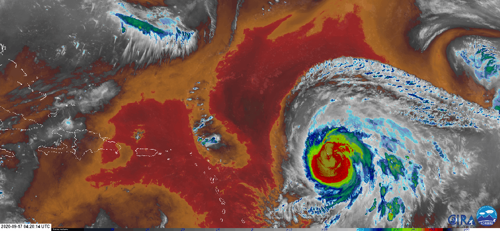
Hurricane Teddy is currently located well east of the Lesser Antilles and is a Category Two hurricane as of the latest National Hurricane Center update. The storm is trying to clear out its eye, which means that it’s likely to be upgraded to a Category Three storm later today. I could go on at somewhat great lengths about all the meteorological dynamics seen in this satellite loop, but that’s not really the point of these updates. The biggest thing you should note is the big red blob northwest of the storm. That’s mid-level dry air that might slow Teddy down a bit in the coming days.
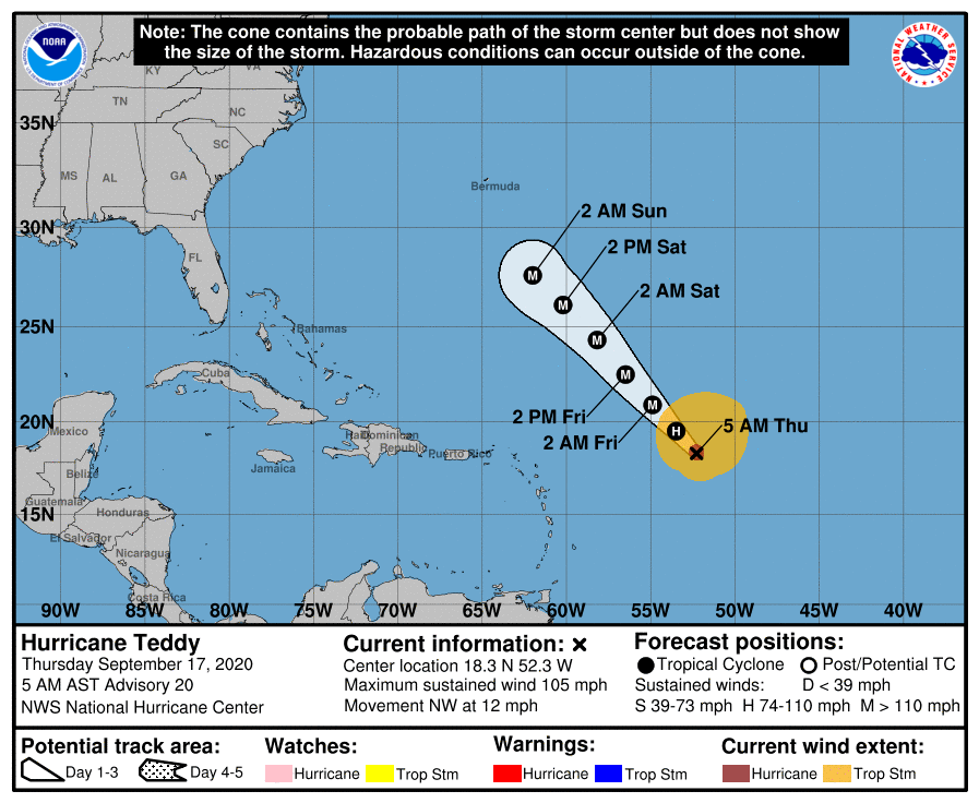
Today through Sunday, Teddy will be stuck on a heading that’s more or less due northwest. This is the official NHC forecast for the storm over the next three days. On Sunday night, the storm could impact Bermuda exactly one week after the island took a direct hit from Hurricane Paulette. This would not be the first time the island took back-to-back hits from tropical cyclones in such a short time. The last such occurrence was back in 2014.
So what happens after Bermuda?

That’s the big question isn’t it. This animation shows the general idea without getting too deep into the meteorological weeds. Basically, the storm turns north somewhere around Bermuda. It wants to go out to sea, but a ridge of high pressure over Newfoundland and an upper-level low off the North Carolina coast may try to steer it back to the northwest in our direction.
Right now, I’m inclined to think that the range of reasonably possible outcomes for this storm is somewhere between something that feels like a strong nor’easter and a nice day but with big ocean swells. Our region is absolutely vulnerable to major hurricane impacts, but to put this storm into that league (i.e. something more impactful than a strong winter storm), it would need to retain part of its inner core. If the storm was racing up the East Coast from the Bahamas, it would have access to a lot more warm water to keep its core alive than the current forecast which is for the storm to back in from the southeast. That’s not to say it couldn’t happen with Teddy but right now, I’m skeptical.
My advice to you is the same advice I’ve given to a few friends and family here along the Maine coast: keep an eye on Teddy and think a little bit about what you might need to do this weekend if it still looks like the storm might head in our direction. Even if we wind up with impacts that are akin to some of our winter storms, your preparations for strong winds and heavy rain might look different in September than they do in January.
I will have many more updates on Teddy in the days to come, especially if it looks like we might actually get some wind/rain out of it.
-Jack
