After a very cold start this morning, expect warming temps throughout the day as southwesterly breezes pick up and usher warmer air in our direction. high temps are likely to occur later in the day than usual as warm air continues to arrive even as the sun sets. Expect highs in the upper 20s up north and in the lower 40s along the coast. A mix of sun and clouds is noted across the region this morning with the cloudiest skies over western NH and the sunniest skies along the Maine coast. Expect high clouds to thicken up a bit today as a disturbance approaches the region from the west. There might be just enough moisture to produce a few stray snowflakes in the north/mountains but otherwise, dry weather will continue.
Today will feature the coldest air of the season so far as northwesterly breezes continue behind yesterday’s cold front. High temps will only get up to around freezing at the immediate coastline where sunshine will be most widespread while the mountains remain stuck in the low to mid 20s under persistent low clouds. Upslope snow showers are still ongoing up in the mountains this morning though they will generally be fewer in number and weaker than those we saw yesterday.
Today will feature continued cooler weather as west/northwesterly breezes continue to push Canadian air in our direction. Expect our usual upslope/downslope pattern to develop for temps/clouds/precip today with sub-freezing highs, overcast skies, and snow showers up north while the coast sees highs in the mid 40s, mostly sunny skies, and generally dry conditions. A weak frontal boundary will cross the region midday and might drag a couple of the upslope snow showers into the foothills. Any precip outside the mountains will be short-lived.
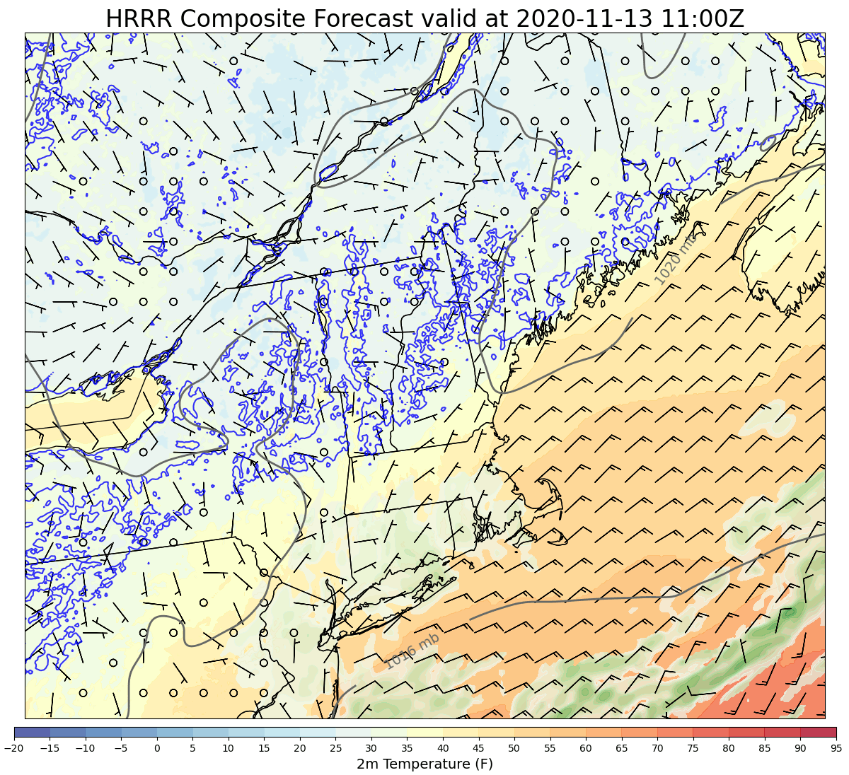
Our weather for the next 24 hours or so will be dominated by an area of low pressure rapidly intensifying over the Great Lakes. The core of the storm will remain well to our west, but it will send a potent cold front in our direction tonight. Ahead of this front, we’ll see morning sunshine give way to overcast by this afternoon. Winds will begin to pick up out of the south/southeast this afternoon in the wake of calm conditions this morning. Temps will increase from around freezing this morning to around 40-45 along the coast by this afternoon. Up in the mountains, cold air damming will hold temps in the low to mid 30s throughout the day.
Forecast map valid 10 PM 11/15
The front will arrive later this evening with precip beginning in NH between 6 and 8 PM. Outside the higher terrain, this one will be all rain. Rain will spread into Maine between 8 and 10 PM. Rain will be quite heavy at times and we should pick up around an inch of precip despite rain only falling for a couple hours in any given spot. Thankfully, the heaviest rain will arrive around 10 PM in NH and around midnight in Maine so unless you’re out and about around then for some reason, you probably won’t notice much of a disruption.
The bigger potential for disruption will arise from strong southeasterly winds that will gust over 40 mph at times along the coast. This is knocking on the door of power outage thresholds and I suspect a few folks will wake up in the dark tomorrow morning. If your location is especially prone to outages, think about what you can do today to minimize that potential impact. The strongest winds will be felt along the Midcoast east of Brunswick.
Breezy westerly winds will arrive tomorrow but they don’t appear to be quite as strong.
Today will feature cool temps (at least relative to recent days) and generally quiet weather as light northwesterly breezes continue to push cooler air into the region from Canada. As a result, we’re seeing our usual upslope/downslope cloud pattern on satellite imagery this morning and that’ll probably continue through most of the day. If you’re along the coast, skies are mostly sunny and if you’re up in the mountains, overcast prevails. There might even be a few snow showers up in the mountains today, but little to no accumulation is expected. Temps will range from around 30 up north to around 50 along the coast.
Today will feature the development of weak low pressure east of Cape Cod which means northeasterly breezes and light rain for us. Temps will be considerably cooler than yesterday as the airmass overhead is now being sourced from Canada. High temps will range from the mid 30s up north to the mid/upper 40s along the southern coast.
We’ll start out mostly dry this morning but as the loop above shows, light precipitation will develop as we move into the late morning/early afternoon. For all except the northern mountains, this will fall entirely as rain. Snow will fall up north and might be able to accumulate an inch or two by tomorrow morning.
Skies will start cloudy in the southern half of the region while northern areas catch a few glimpses of early morning light before overcast arrives in a couple hours. The whole area will then be overcast for the rest of the day.
Today will feature the beginning of the end for our run of extremely unusual late-season warmth. A cold front moved through the region early this morning and behind it, we’ll see westerly/northwesterly winds pushing cooler air into the region. That said, with temps currently in the low to mid 60s across much of the coastal plain (!!), it’ll still feel pretty warm today even as the cool air works its way into the area. Temps will drop steadily today so whatever you’re at now will be your high temperature. By this evening, the mountains will be in the mid 30s and the coastline will be around 45-50.
Skies are overcast across the area this morning thanks to moisture streaming north from Tropical Storm Eta down in Florida. None of that moisture seems able to make it to the ground north of Long Island or so, and that’ll probably continue through most of the day. That said, a new wave of low pressure appears likely to form along the cold front this afternoon. This may graze the coastline with a brief round of showers after 4-5 PM.
Our stretch of highly-unusual warmth is coming to an end tonight as a cold front moves through the area. That means today is the last day we’ll be able to enjoy temps in the upper 60s to low 70s for a while. As the front approaches today, glimpses of morning sunshine will quickly fade behind thickening clouds. A few showers may try to develop in western NH later this afternoon but the bulk of the precip expected from this front will move through overnight into tomorrow morning and will mostly fall in NH.
Our extended streak of mild weather will continue today as winds remain out of the southwest and low pressure remains well to our west. Skies on satellite imagery this morning are mostly clear though a few spots inland and between Brunswick/Augusta might see a brief period of fog early this morning. Otherwise, it’ll be another day of clear skies and warm temps with highs ranging from the mid 60s along the midcoast to the mid 70s in southern NH and adjacent parts of interior SW ME. A few high clouds might drift across the area this afternoon but otherwise, sunshine continues.
More seasonable weather appears likely to return by the end of the week.
Nothing substantial about our weather pattern looks to change for today. However, the addition of a little more moisture to the air means that we’re seeing fog develop along the coastal plain and some parts of the foothills too. This fog is quite dense in spots so watch out if you’re heading out and about this morning. Fog will burn off shortly after sunrise inland, but light onshore flow will make that task considerably harder closer to the coast. I think most spots near/along the Turnpike should see sunshine by this afternoon and Portland should at least see a few bright moments. I’m much less optimistic about anywhere along the Midcoast. There’s even a chance of some drizzle along the Midcoast where the fog is thickest.
High temps today will range from 75 in southern NH to around 70 in the interior Maine foothills to 65 in the mountains and 55 along the coast.