Today will feature warmer temps, cloudier skies, and some light precipitation as we welcome our next storm system into the area. Before rain and snow arrive this afternoon, expect clouds to finish overspreading the region from the southwest over the next couple hours as calm and cold conditions give way to light southerly breezes and rising temps.
By 1PM, the time at which this forecast map is valid, most spots should be seeing overcast skies with temps a few degrees on either side of freezing. Precipitation will arrive in SW NH shortly after 1 PM before spreading northeast into Maine later in the afternoon.
The map below shows expected conditions at 6 PM when the steadiest precipitation will be impacting the area.
This system is disorganized so we’re not expecting much if any precipitation to be heavy, but as a little “mesolow” spins up east of Portland, bands of moderate to perhaps even heavy snow may briefly impact the coastal plain. The immediate coast seems likely to be just a smidge too warm for accumulating snow, but if you’re anywhere north of Route 1 along the Midcoast or west of 295/95, expect this one to be mostly snow (I believe the model shown above is probably a smidge too warm on the margins based on current temperature data).
Here’s a look at how much snow to expect this evening. Most spots won’t see more than an inch, but the best shot at 1-3″ looks to be from near Windham to Lewiston to Augusta and points northeast. Though a few bursts of snow may be heavy this evening, this isn’t a significant event. Just take it slow and keep an eye out for slick spots if you’re driving when the snow is falling.
Right along the coast, it looks like temps will be just a smidge too warm for snow, but as always there’s a bit of uncertainty in the exact rain/snow line. Thankfully it’s only an inch or two instead of a foot or two of snow at stake this time!
Today will feature cool temps and clear skies as high pressure moves overhead. After starting a few degrees on either side of zero this morning, temperatures will warm up a little above yesterday’s highs by this afternoon. Northern spots will be lucky to hit 20-25 while far southeastern NH may make a run at 32.
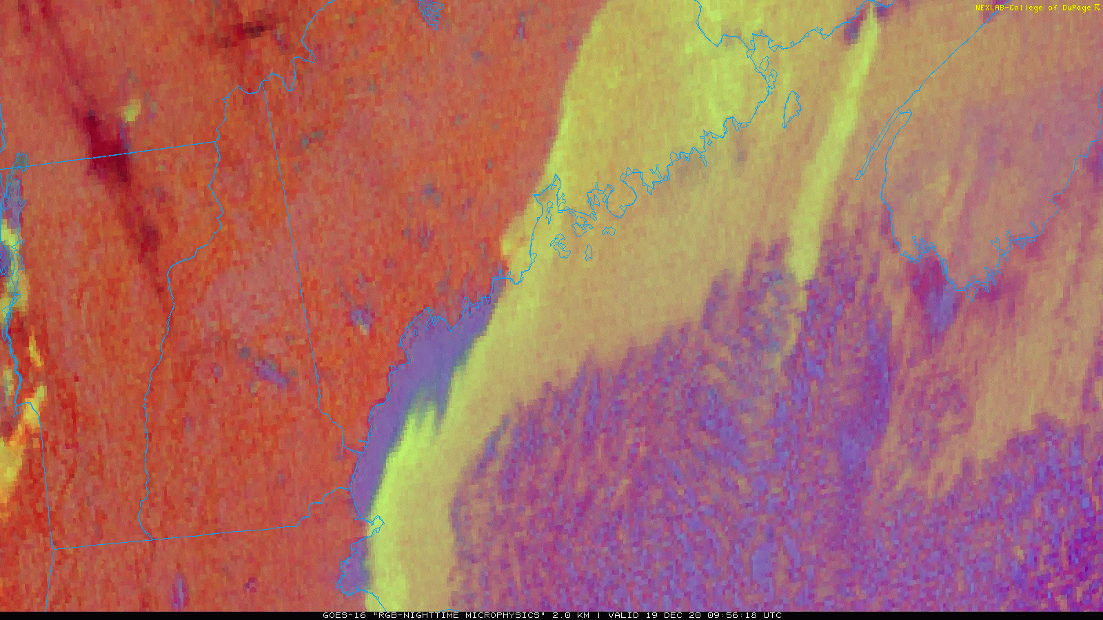
This satellite loop shows clear skies over the region this morning with one neat exception” some lake effect downwind of Sebago Lake. Usually, Sebago is either too small or too frozen to support lake effect clouds. The ingredients have come together today because we have cold air while the lake is still open, and light NNW winds oriented parallel to the lake’s major axis (long side) allow air parcels an unusually long time over water to pick up heat and moisture. I’m not sure if these clouds are deep enough to produce any snow, but if someone happens to be heading down Rt 25 west of Windham this morning, I’d be really curious to know!
Anyways, aside from those couple square miles our skies are clear this morning and will remain so until cirrus arrives from the west this afternoon ahead of our next (weak) storm slated to arrive tomorrow with some light snow.
Yesterday’s storm is now sliding away into the Atlantic which means high pressure is en route to our area today. Ahead of this high, look for clearing skies (just a few more low clouds to get rid of along the coast), cool temps, and continued northerly breezes. Northerly breezes will be strongest along the Midcoast but shouldn’t exceed 20-25mph. That’s definitely not enough for power outage issues but given the fact that many spots have over a foot of very dry snow on the ground, blowing and drifting could lead to some slick spots on the roads here and there.
High temps today will remain on the chilly side, ranging from around 15 up north to around 30 right along the coast.
Our nor’easter has arrived this morning and is progressing more or less as forecast.
Radar imagery and observations from the surface show a band of very heavy snow extending from Albany NY through southern NH into York County ME as I write this around 6 AM. Snowfall rates in this band have been measured between 2-3″ per hour and there were even signs of thundersnow near Keene! I think this band has reached its “high water mark” as far as latitude goes over NH but probably has another 20-40 miles to come north into the Maine coast.
The leading edge of the snow has pushed into northern NH and parts of central Maine though dry air is still holding strong northeast of Lewiston. This trend will likely continue through most of today even as our storm (and its associated forcing for snow bands) moves northeast. I still like the Fryeburg-Lewiston-Camden corridor as the northern edge of sustained heavy snow but perhaps we might end up a smidge farther north than expected.
This is the snowmap I posted yesterday evening, and I’m still feeling pretty good about it.
The heaviest snow will fall between now and noon before tapering off from west to east this afternoon.
Temps will remain quite chilly throughout the day, ranging from around 15 up north to perhaps as high as 20 in southern NH.
Remember to watch out for blowing/drifting snow throughout the storm and even for a while this afternoon after most of the accumulating snow is done.
We’re about 8-12 hours away from the onset of snow here in the area which means it’s time for one last crack at this forecast before we sit back and see what happens.
On a large-scale, the forecast outlined this time yesterday is more or less on track.
via COD NEXLAB
The swirl we were tracking across TX/OK yesterday is now moving northeast through TN/KY and moisture is streaming north out ahead of it. Meanwhile, our Arctic airmass is well-entrenched and saves us the hassle of worrying about a rain/snow line. The problem is that said airmass might be a little too entrenched and it’s as dry as it is cold. Therefore, snow is going to struggle to make it to the ground over most of the area tonight and perhaps for much of tomorrow too.
Here’s a look at regional radar imagery and surface precipitation observations as of 4 PM. Snow is falling west and south of NYC with some rain/ice mixing in east of I-95 south of Philly. Farther north, low-level dry air is preventing snow aloft from making it to the ground.
The big question is just how stubborn that dry air is going to be over the next 24 hours.
via Levi Cowan/Tropical Tidbits
The trend in high-resolution weather model guidance over the past day or so has been towards that dry air being more stubborn than originally forecast. This is supported by surface observations today showing the area of high pressure over Quebec a bit stronger than expected. It also fits a bit better with what’s historically expected from a setup like this. Remember in yesterday’s forecast we talked a bit about how the fact that this storm was weakening and not strengthening as it approached the region gave some pause about the higher-end snow forecasts. Sure enough, it appears that skepticism was warranted.
With all this in mind, here’s one last crack at a snowfall accumulation map for the area.
I’m still quite confident that the heavier bands will be able to work their way into southern NH and York County ME. That’s where the jackpot will be for this storm and over a foot is likely here. The mountains seem likely to miss out almost entirely which is a real bummer for those of us hoping to ski some fluffy snow this weekend. The forecast challenge is really figuring out points in between. I suspect the real gradient will be a lot sharper than it appears on the map here. You might only have to drive 10-20 miles to get from dustings to nearly a foot, but beyond the idea that this is most likely to happen somewhere between Fryeburg-Lewiston-Camden, there’s no way of knowing exactly which towns will fall on which side of that gradient.
Snow is still on track to start in SW NH later this evening before struggling northeast into SW Maine tomorrow morning. Snow will reach its maximum northern extent sometime midday tomorrow before departing to the east tomorrow afternoon.
Whatever snow is able to fall will not hesitate to become airborne once again as northeasterly breezes pick up and the frozen ground prevents much if any melting.
The nor’easter discussed in great detail yesterday afternoon is still on track to arrive late tonight from southwest to northeast with moderate/heavy snow. Before the first flakes fly, we’ll enjoy quiet and cold weather today thanks to a strong area of Arctic high pressure.
A quick look at surface analysis and observation data this morning shows that big high pressure area over Quebec while our developing storm is currently split into two components over TN and off the SC coast. All the little numbers you see are temperature observations. If you haven’t yet stepped outside this morning, make sure to bundle up when you do so! Temps across the region range from around 10 below up north to around 10 above in the south.
Skies right now are mostly clear, but morning sunshine won’t last long as clouds approach from the southwest ahead of the storm. By mid-afternoon, the entire region should be seeing overcast skies.
As we move into the later afternoon hours, calm conditions will gradually give way to light northeasterly breezes as the storm’s snow shield gets closer.
While not shown on this map, I’m thinking ocean effect snow showers are possible along the NH Seacoast and adjacent parts of York County starting around 4-5 PM. We don’t quite have enough of an easterly component to the winds for much accumulation but an early dusting is possible in some spots before the primary round of snow arrives later tonight.
By 9 PM, snow should begin falling over far southwestern NH while the rest of the area remains cold and dry. Snow will slowly struggle northward overnight as low-level dry air erodes. Just how fast and far north this process can occur will determine snowfall totals especially for spots north of Brunswick-Lewiston-Fryeburg.
Here’s an updated look at what I’m thinking for snowfall totals from this system. There really haven’t been any significant changes from yesterday’s forecast, though I trimmed amounts back a smidge on the northern edge. When all is said and done, the observed snowfall map will have a really sharp gradient somewhere near where my 4-8″ swath is. Amounts north of that may struggle to reach 2-4″ while points just south could exceed 12″. Unfortunately there’s just not quite enough confidence to try and pin down that gradient location more precisely. Perhaps we’ll get some more clues with today’s model guidance and observational data. If that information indicates that noteworthy changes might be needed to this snow map, I will have another update this evening. Otherwise, we’ll go with this forecast and wait to see how it turns out.
Another aspect of the storm worth mentioning is the possibility for near-blizzard conditions as our fluffy snow is blown around by gusty northeast winds tomorrow.
This map depicts the chance that a given point will see <0.5 mile visibility with snow and winds over 30 mph. Because this product uses sustained winds instead of gusts, the highest probabilities are concentrated heavily offshore but coastal spots particularly in southeastern NH and south of Portland in Maine are likely to make a run at blizzard criteria (visibility <=0.25 miles with frequent gusts >=35mph for three or more hours) tomorrow morning. We might fall just short (hence the lack of blizzard warnings from the NWS) but the impacts will be similar regardless.
Another nor’easter is in the forecast for Thursday and, as per usual, the forecast is shaping up to be a tough one. We know there will be enough cold air for precipitation to remain all snow, but it’s less clear how much moisture will be able to make it to our area given that the track of the storm is expected to be a little farther south than what would usually be considered a blockbuster for ME/NH.
This post will be divided into two parts, an in-depth analysis of some of the meteorological processes and thinking underlying the forecast, and then a quicker rundown of what to expect. If you’re looking for the latter and less interested in the former, scroll down to the second set of large bold lettering.
Forecast Analysis
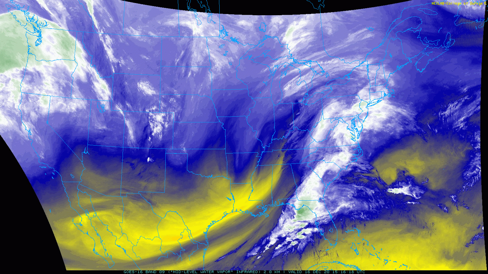
As I write this on the afternoon of Tuesday 12/15, I’ve been carefully watching water vapor satellite imagery.
via COD NEXLAB
The swirl of primary interest to us is that which is currently located over Oklahoma. Unlike many of our big snowstoms, this is the only disturbance that will drive our snowfall though other swirls on the map here will play supporting roles. If we had another disturbance diving southeast out of Northern Canada, this would be a much different conversation. But as it is, we missed our shot with one of those yesterday. To get a sense of what can happen when an Arctic disturbance gets involved, check out that storm near Newfoundland!
via COD NEXLAB
Here’s a look at what I’m seeing when I look at that loop. The features of most importance to our forecast are highlighted with the various colorful annotations. That giant storm over Newfoundland shows up well and has dragged an intense shot of Arctic air into the region on northwesterly winds today. In the other corner of our image, a collection of Pacific disturbances is sliding onshore over British Columbia. They will eventually be forced to turn southeastward by NW flow around a ridge west of California.
Finally, our primary disturbance is clearly visible over Oklahoma, and it’s already giving us some clues about its structure when it arrives over the East Coast. Check out the dry slot wrapping around the southern side of the low. This feature is typical for upper-level lows, and it will remain a player in the forecast as the low heads east-northeast over the next couple days, even as it starts to tap the moisture-rich subtropical jet noted over the Gulf of Mexico.
To more carefully investigate the structure of this upper-level low and its accompanying dry slot, let’s zoom into the southern Plains and look at radar imagery, surface weather observations (little icons), and upper-level heights (orange lines).
The center of the ULL when I made this graphic was over the NE TX Panhandle according to the height analysis shown here. Radar imagery and surface observations show precipitation focused along and just north of the upper-level low’s track. Remember this is because the dry slot is located south of the low and is inhibiting the development of precipitation.
Tonight, the upper-level low will shift off to the east and weaken a bit as it starts to encounter large-scale confluence (a convergence of upper-level winds somewhat analogous to merging highways) between the storm over Newfoundland and a ridge over the Bahamas.
By preventing the upper-level low from moving too far north, this confluence will set a northern limit on snow Thursday. Figuring out exactly where that northern limit is will be the challenge occupying myself and many other forecasters over the next few days.
One key part of the puzzle is a subtle secondary disturbance diving southeast into the Dakotas tomorrow morning. This disturbance is part of that collection we saw over British Columbia on the WV maps above. Because every action has an equal/opposite reaction, the more this secondary disturbance can dig south, the more our upper-level low can move north.
For those who follow along with weather model guidance, you’re probably aware that over the course of the day today, most model guidance has been trending towards a storm track farther NW.
via Levi Cowan/Tropical Tidbits
As this animation shows, this trend is due in part to new forecasts showing that Dakotas trough digging farther south tomorrow.
Whatever happens with that secondary disturbance, our primary disturbance will reorganize a bit as it moves over WV/MD tomorrow evening but its overall trend is towards weakening as it moves from the Mississippi Valley towards Nova Scotia.
This is a big reason to be skeptical of some of the really big snowfall totals that you might see floating around on social media, be it for our area (ME/NH) or points farther south. It’s hard to get widespread 18-24+” of snow in the Northeast, and it’s really hard to do that if you don’t have a rapidly intensifying storm, much less one that is weakening aloft.
While this system does not have the right upper-level configuration to drive widespread extremely heavy snow, the ingredients will come together for some heavy snow starting tomorrow evening.
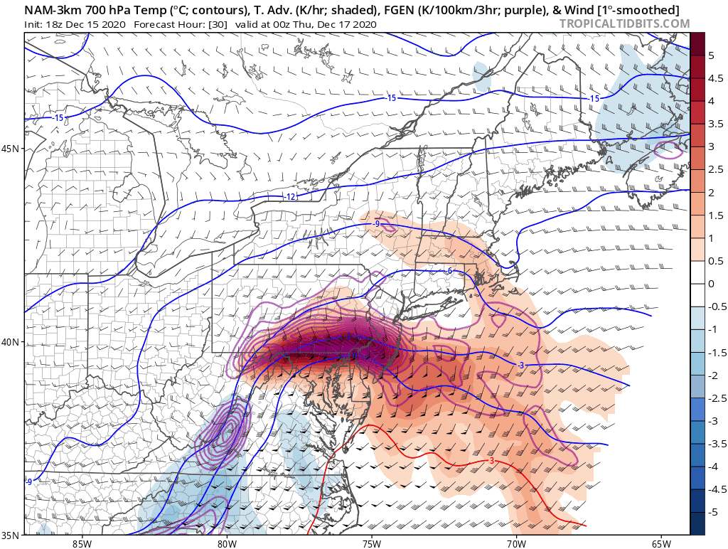
At the jet stream level, this is so close yet so far to being a classic “coupled jet” pattern favorable for rapid cyclogenesis. A cyclonically-curved jet streak extends from Georgia up into the Mid Atlantic while its anticyclonically-curved counterpart extends from Quebec City east into New Brunswick. Jet streaks are just pockets of enhanced winds embedded within the larger jet stream and because they don’t move forward as fast as the air within them, they stir up some circulations in the lower atmosphere to make sure no one part of the atmosphere “runs out” of air.
The portion of these circulations we’re interested in are the horizontal transportation of low-level air from regions outside the jet entrance/exit regions and the subsequent vertical transport of that air up towards the jet stream level. In this case, the air we’re transporting horizontally is coming from the Gulf Stream and thus is rich in subtropical moisture. When that air is then lifted up towards the jet stream, it cools and the moisture it contains condenses/freezes.
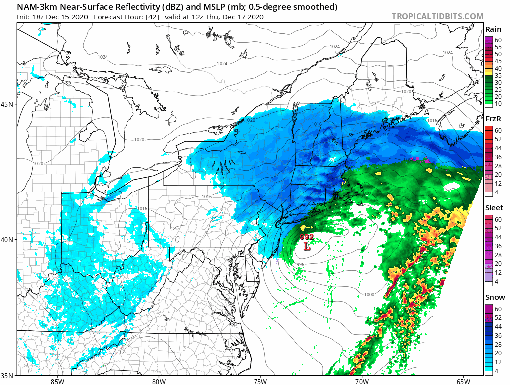
This forecast radar map for the same time as that jet stream map confirms the anticipated consequence of these processes.
By tomorrow evening, steady snow will be falling across much of southern New England and southern/central NY.
We can also see this process at work by examining forecasts for slightly lower in the atmosphere (5,000 feet vs 35,000 feet). You can see the wind barbs at this level showing the low-level jet we inferred by analyzing the jet stream pattern above. You can also see that low level jet drawing subtropical moisture northward around the southeastern flank of the low near New York City. Our area will be the battleground between that subtropical moisture and extremely dry Arctic air to the north.
One way of visualizing that battle is a cross-section of relative humidity tomorrow evening shown below.
via Levi Cowan/Tropical Tidbits
Note that near point A (north of Bangor), there’s a layer of very dry air from around 750 hPa (12,000 feet ish) to around 950 hPa (1000 feet ish). Even though snowflakes are able to form above that, they sublimate as they fall through that deep layer of dry air and thus don’t reach the ground. As you move farther SW down the cross section towards point B, you can see that dry layer shrink until eventually it disappears. For somewhere like Bangor, it will take a long time for that layer to disappear (if it does at all) so most of the storm’s snow will be lost to evaporation. For spots near point B (southwestern NH), this dry layer will be overcome fairly easily so snowfall totals will be considerably higher.
via Levi Cowan/Tropical Tidbits
As the storm moves by on Thursday, bands of moderate to heavy snow will be focused by a process known as frontogenesis (the creation of a new front). The problem though is that by the time the storm gets here, the front will be basically created already and thus frontogenesis, having done its job, will be packing up and leaving. You can sort of see this happening in the loop above where frontogenesis is outlined in purple contours. Remember that aloft, the storm will be weakening on approach to Maine and exactly how quickly that happens will determine how much snow we get.
Whatever snow we do get looks to be quite fluffy thanks to excellent snow growth conditions.
via Levi Cowan/Tropical Tidbits
The quintessential six-sided dendrites that pile up most efficiently like to form in moist conditions between -12 and -18C where air is rising quickly. The more of the atmosphere you have satisfying those conditions, the fluffier your snow will be (cold temps near the surface help too). Here, our DGZ (Dendritic Growth Zone) extends from around 5,000 feet aloft to around 16,000 feet which is unusually deep. Moisture and lift appear to be available in plenty throughout this layer, so we should be good to go for fluffy snow across the area as the coastal front shrinks away towards Cape Cod.
The trough axis will cross the region Thursday afternoon and sinking motion behind it will put an end to precipitation from west to east.
Forecast Overview
Snow will arrive from southwest to northeast tomorrow night after a chilly and mostly cloudy day.
As the storm moves northeast on Thursday, snow will become steadier and heavier at times across the area. The best chance for heavy snow will be in southern and western parts of the region, and the model depicted above may be overstating the northwestern extent of steady/heavy snow on Thursday. This will be a fairly fast-moving system and snow will come to an end from west to east Thursday afternoon/evening.
How much snow will there be?
Here’s my best guess. Highest totals will be in southeastern areas and lowest totals will be up north, but how high and how low those totals are is a tricky question to answer. In a bit of an experiment, I’ve included “boom” and “bust” forecast scenarios for each region along with estimated probabilities that each of those scenarios will occur. Note that the risk of a “boom” (more snow than expected) is higher in the south while the risk of a “bust” (less snow than expected) is higher in the north where Arctic air may well prove to be more stubborn than we currently think.
I’ll have another update on the forecast for this storm tomorrow.
Well east of our area this morning, the storm system that brought light snow to parts of the area yesterday is undergoing a stunning transformation into a powerful North Atlantic cyclone.
Over the course of the day, this storm’s central pressure will drop to that which we’d expect to see in a Category 3 or 4 hurricane (935-945mb). Why is this important? Wind is driven by pressure gradients, and the fact that we have such a strong area of low pressure not all that far off to our northeast means that there will be a strong pressure gradient over the area today. Therefore, it will be quite breezy.
Expect NW winds ranging from 30-35 mph in northeast parts of the area closer to the low and 25-30 mph in southern NH farther from the low.
A quick back trajectory analysis shows that the air arriving in our area this morning has come straight from the Canadian Arctic, carefully avoiding bodies of water that might take the edge off the chill. That means that it’ll be quite chilly in addition to windy.
Given that this is the airmass moving into the region today, high temps are pretty much what you get when you wake up (high 10s north, around 30 right at the coast). The weak December sun will battle the arriving chill to a draw this morning, leaving temps about where they are now until we really begin to fall off around sunset tonight.
By tomorrow morning, temps will have fallen to around -10 up north and around +10 in the south. Leftover NW breezes will actually keep these numbers a smidge higher than they might otherwise be, but of course will also drive wind chill values right into the ground. Wind chill advisories are up for parts of the mountains where -20F chills are expected. Though the rest of the region looks to fall just short of advisory criteria, it will still be wise to properly bundle up if you’re headed outside even for a short time.
Our next storm is still on track to arrive late tomorrow night into Thursday morning. This storm, passing well south of the region, will be all snow but we don’t yet know just how far north the moderate/heavy bands might be able to make it. Right now, the best chance for >6″ of snow is in southern NH and parts of Maine south of Portland. Snowfall totals will quickly taper off to around 0″ up in the mountains. With such deep cold in place, whatever snow does fall will be quite fluffy. Much more on this storm either later today or tomorrow.
Today will feature cooler temps and continued unsettled weather as another wave of low pressure develops and passes to our south. This storm will slide just far enough offshore that we won’t see significant impacts, but it will bring a period of light rain/snow to southern areas this afternoon.
Here’s a look at the pattern across the eastern US this morning. Our storm is currently over far NW South Carolina and is racing off to the east-northeast. This storm is loaded with moisture but most of it will stay off to our south, deflected by the incoming Arctic front. This is *almost* a perfect setup for a massive snowstorm but alas the ingredients are just a little out of place.
Snow will start falling lightly later this morning across western NH.
By this afternoon, flurries will be spreading into Maine and we’ll start to watch for the development of an elusive NORLUN trough which is depicted here on the HRRR model’s forecast radar imagery. A NORLUN trough is basically a mini-front that marks a boundary between cold air to the west and moisture-rich air to the east. Convergence and some instability along the trough axis helps to force a band of narrow but somewhat heavy snow (or rain). Right now, guidance is suggesting this band might set up somewhere between Brunswick and York. This NORLUN trough isn’t strong enough or long-lasting enough to produce a prolific event but it could drop 1-3″ over a relatively small area while the rest of the region will be lucky to pick up a dusting-1″.
Flurries will taper off this afternoon outside the mountains where strengthening upslope flow will keep snow showers going.
Arctic air pours into the region tonight and tomorrow ahead of our next storm scheduled for Thursday.
Temps today will range from the upper 20s up north to the mid/upper 30s along the coast south of Portland.
Today will feature mild weather and somewhat widespread drizzle/light rain as last night’s storm moves off to the northeast and we wait for colder air to arrive from Ontario. Temps this morning are generally in the mid to upper 30s as cold air damming remains locked in place. This means that there’s a shallow layer of cold air right at the surface below much warmer air aloft. As the cold front moves through this afternoon, it will stir our atmospheric pot a bit which means that the thin layer of cold will get “mixed out” and temps will jump sharply. Where this occurs during the afternoon together with some patchy sunshine and downsloping westerly winds (southern/western NH), temps could get really toasty (mid 50s). Where this occurs after sunset (most of Maine), temps won’t really jump up that much before cooling due to the arrival of our new airmass. So highs in most of Maine won’t be far from where temps are now: in the mid to upper 30s.
Drizzle will be most widespread along the Maine coast and adjacent parts of the foothills. That drizzle will come along with a fair bit of fog too, especially this morning. So while above-freezing temperatures mean that outside of the really sheltered mountain valleys, there won’t be any travel concerns today, it’s not exactly going to be picture-perfect for outdoor activities.