
Hello everyone!
Today will feature the arrival of our next storm system from the southwest, a fast-moving coastal low that will bring light to moderate snow across the region today. Snow will start around or a little before noon in southern New Hampshire, around 1-2 PM in western parts of Maine, and around 2-3 PM for points farther northeast.

Before precipitation begins, skies will be mostly cloudy (except for some early breaks of sun in northern areas) and temps will rise into the upper 20s north and low to perhaps mid 30s in the south. Much like on Friday, temperatures will cool as precipitation begins to fall so outside a few stray raindrops right along the shoreline, this will be an all-snow affair. The map above shows expected conditions around 2 PM with snow falling across most of the area despite the freezing line (solid blue line) hung up in the foothills.
As we move into the afternoon, a band of moderate to heavy snow is likely to develop near the coastline. Rising air associated with this band will help boost snowfall rates up towards an inch or so per hour. What goes up must come down, and that means sinking air over the foothills and mountains which will see precip dry up during this time. Exactly where these bands of rising/sinking motion set up is more or less impossible to determine ahead of time, but will have a substantial influence on final storm totals.

This map shows the expected development of heavier snow closer to the coast and the end of snow inland around 5 PM. Also note that after a couple hours of precipitation, the freezing line has retreated to the shoreline.

Snow will rapidly depart to the east this evening as colder and drier air surges in from the northwest. On the leading edge of this new airmass, moisture from the Great Lakes and increased instability will likely support a few heavy snow showers/squalls. As per usual, these squalls will be most potent in the mountains but could bring one final coating to the coastline as well. Thankfully, the timing of these squalls between 10 PM and 1 AM is helpful for minimizing their impact to travel.
As far as snowfall totals go, here’s the same map I posted yesterday.
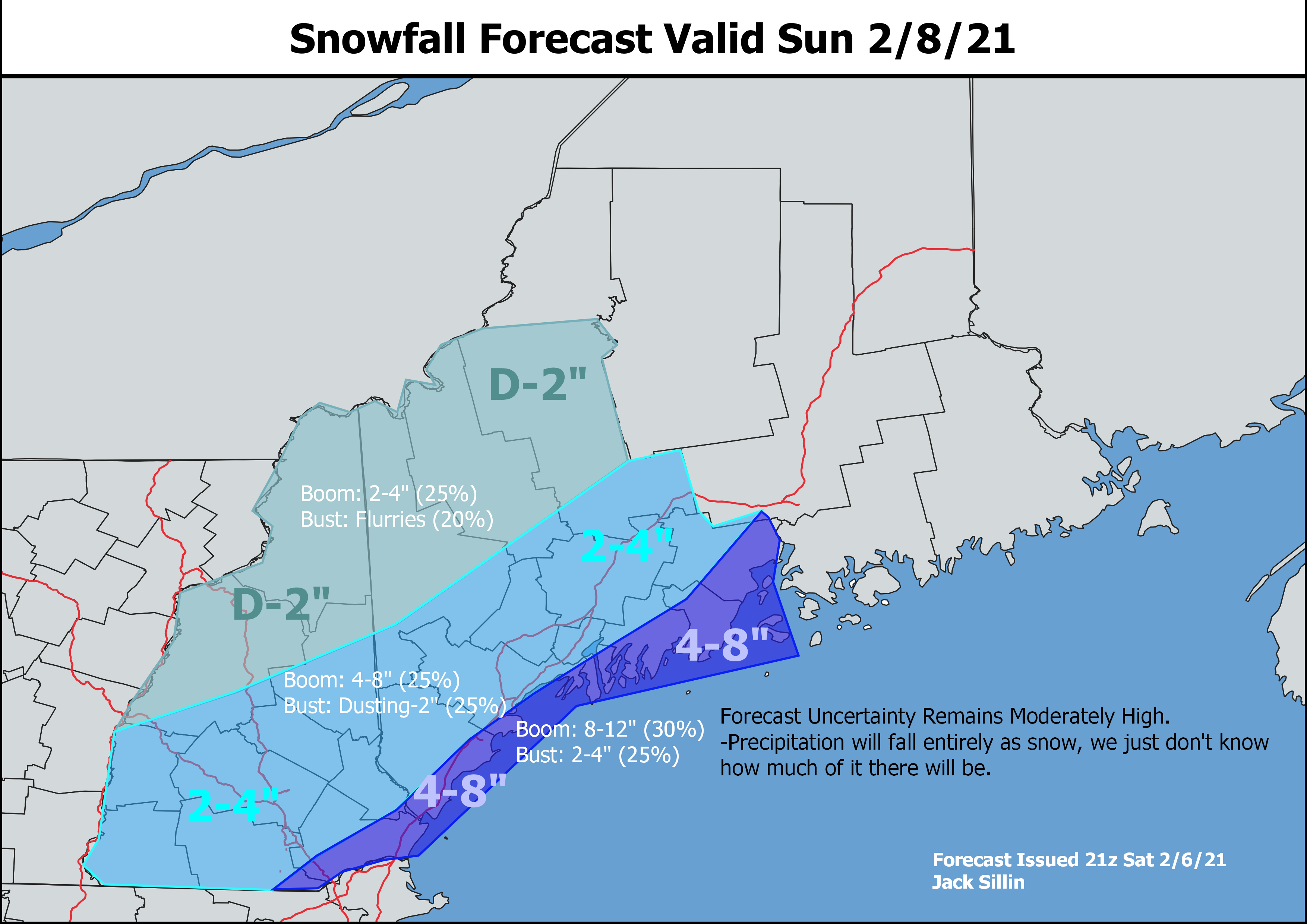
After looking at the latest information this morning, I think we’ll probably come in near the lower end of these ranges especially in southwestern NH. Right along the coast, 3-5″ reports will be more common than 6-8″ reports but I’m not willing to totally shut the door on some locally higher totals yet, as the possibility still exists for a mesoscale snow band to drift just far enough northwest to push a few spots towards 5-6″.
As a side note, I decided at the beginning of the winter to keep the same snowfall map ranges (2-4,4-8,8-12 etc) every storm for the sake of consistency and having a constant frame of reference. That’s why I’ve drawn 2-4″ and 4-8″ contours even though 1-3″ and 3-6″ would probably do a better job of capturing the most likely range of outcomes. Balancing the most helpful ranges for each individual storm with the benefits of consistency across the whole season is tricky, but hopefully this isn’t too far off.
We’ll get a day off tomorrow before our next storm moves in on Tuesday. That one also looks to be a light-moderate snow event, though it will include the mountains and foothills in addition to the coastline.
-Jack
