All posts by Jack Sillin

I’m a third-year atmospheric science student at Cornell University who has been blogging about the weather since 2011. While I’m not officially a meteorologist, I have accumulated a bit of experience forecasting both local weather (in western Maine and New Hampshire) as well as national/international weather during my time writing for weather.us and weathermodels.com. I also have experience programming in Python, teaching concepts in weather forecasting, and communicating forecast information to general audiences.

Tricky And Snowy Setup Tomorrow Night Into Monday

Hello everyone!

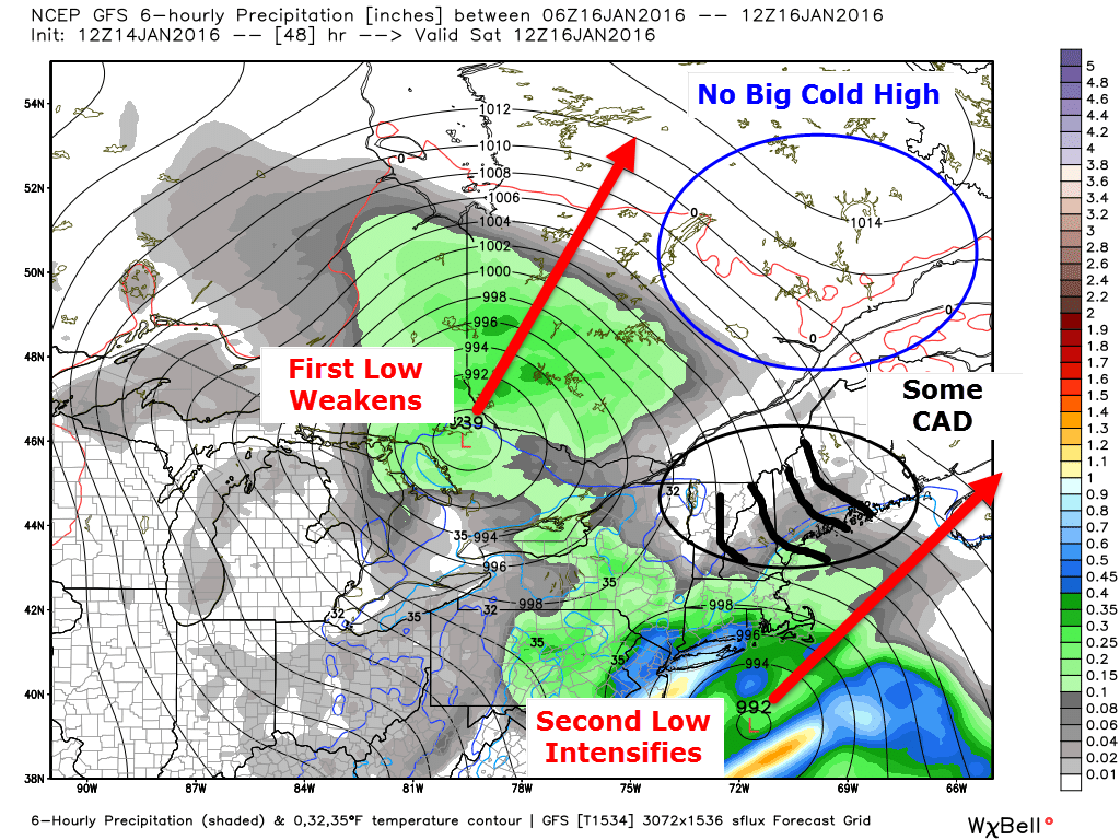
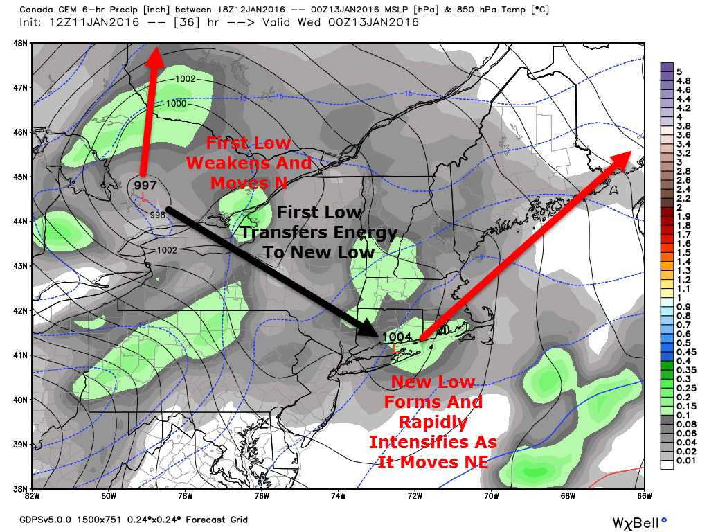
After a nice little storm today, we turn sunnier and cooler tomorrow as low pressure moves east. Another low is already developing in the Gulf of Mexico and will be moving offshore well to our SE Monday. Normally, this would be a slam dunk miss but a strong upper low will be driving SE and there’s a lot of energy on the leading edge. Surface low pressure will develop over the Great Lakes in response to the upper low and a surface trough will develop between the Great Lakes low and the offshore low. This sets up a tricky forecast for Monday as this trough could take on some Norlun traits leading to narrow and possibly heavy snow bands.

12Z GFS Showing A Very Favorable Setup For A Norlun Event. Image Credit: Accuweather

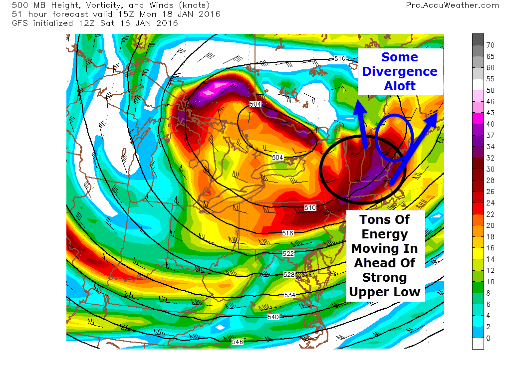
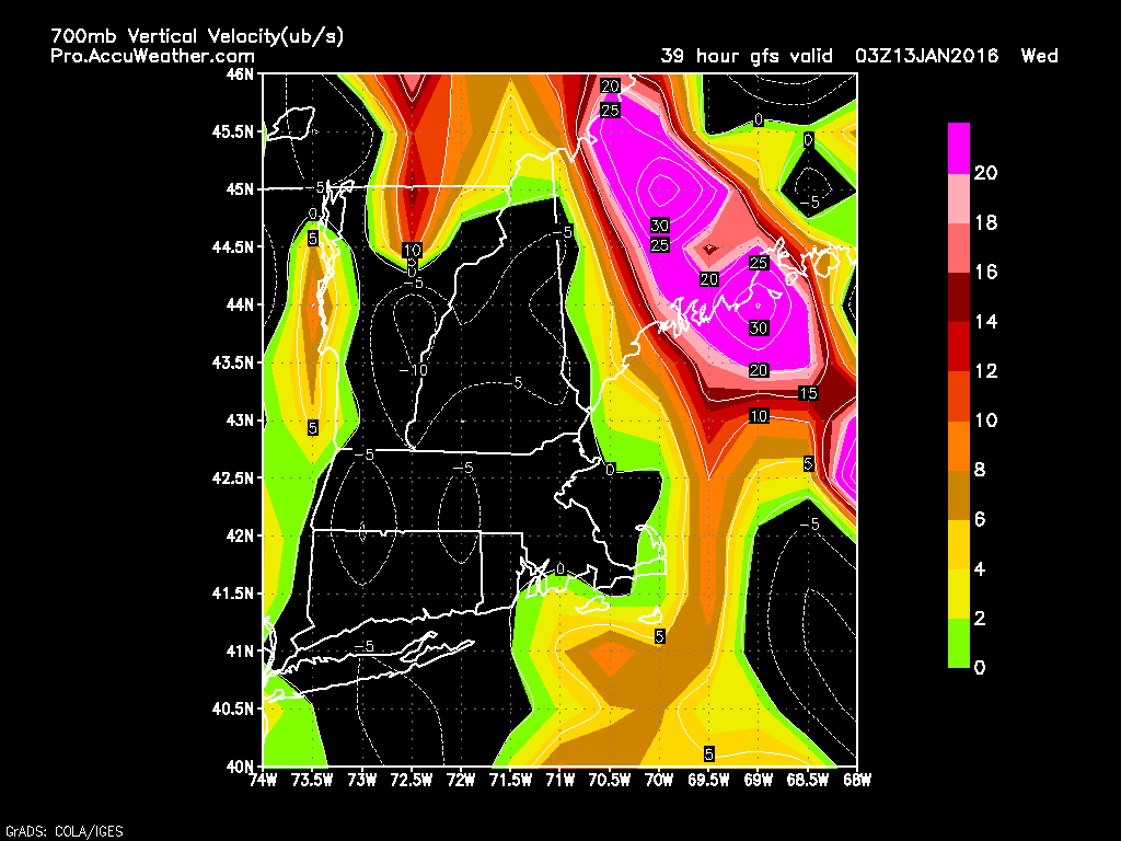
Looking at the 500mb setup, there are a lot of things going for a Norlun event. A strong upper low is moving in from the NW and on the leading edge, a strong peice of energy is moving right over us. Also, being ahead of the upper low, the flow aloft is divergent. To put this in simpler terms, the air at 20,000 feet is spreading out. This leaves a void that air from below must rise to fill. Think of what happens when you pull your hands apart on the surface of a lake or bath. Water rises to replace the water you pushed to the side. This rising motion helps generate precip. This is how everyone will see a coating to an inch or two of snow tomorrow night into Monday morning. The real fun is along the southern coast with a Norlun trough.

18Z RGEM Showing The Surface Setup Monday Morning. Image Credit: Weatherbell

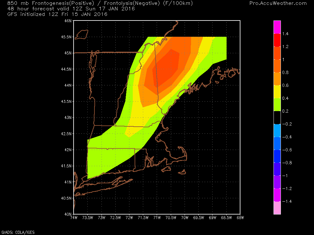
At the surface a storm will blast by well SE tomorrow. Another weak wave will develop over the great lakes. The link between the two will manifest itself in the form of a Norlun trough extending NW-SE across the area. Everyone sees light snow from synoptic (large) scale divergence aloft but any moderate snow amounts will be dominated by a mesoscale (small) norlun trough. These troughs generate narrow, heavy snow bands (think lake effect type) that can drop moderate to heavy accumulations in one town while the next town over sees some flurries and maybe a coating. My point here is that uncertainty is quite high.

Graphic Showing How A Low Forms Off The Maine Coast With Strong West Winds. Credit: Me

Another thing to watch out for with Norlun type events is the threat for a mesolow to develop. Mesolows are caused by rising air along and near the trough and also westerly winds accelerating and veering as they move from a high friction environment (over land) into a low friction environment (over water). Imagine the right front tire of your car running into a patch of ice. As that tire moves from a high friction environment (pavement) into a low friction environment (ice) it accelerates while the left front tire is stuck on the high friction pavement and can’t move as fast. The result is your car spinning out. The same thing happens with air moving from over land to over water. Above I’ve drawn up a quick graphic showing how west winds and a cold airmass emerging over water can generate a low. The divergence aloft and strong upper energy aids in this process. This doesn’t happen behind every cold front because often the air is and sinking. The air monday will be rising due to the approaching upper low/divergence which will help with the development of the low.

12Z CMC Showing The Potential For A Mesolow Along The Coast Monday Afternoon. Credit: Weatherbell

The 12Z CMC shows this potential well. Should this occur, most of the coast could see a moderate snowfall and amounts would be slightly less dependant on the fickle Norlun. While most models don’t show this, based on warm waters (still over 40 degrees!), rising air ahead of the upper low, the strong energy aloft, and the movement of the surface airmass, I think there is a good chance some sort of mesolow develops and strengthens tomorrow afternoon.

93aecdd9-1793-4753-9c30-c7e6221b4c10

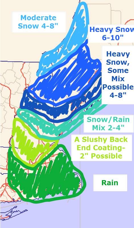
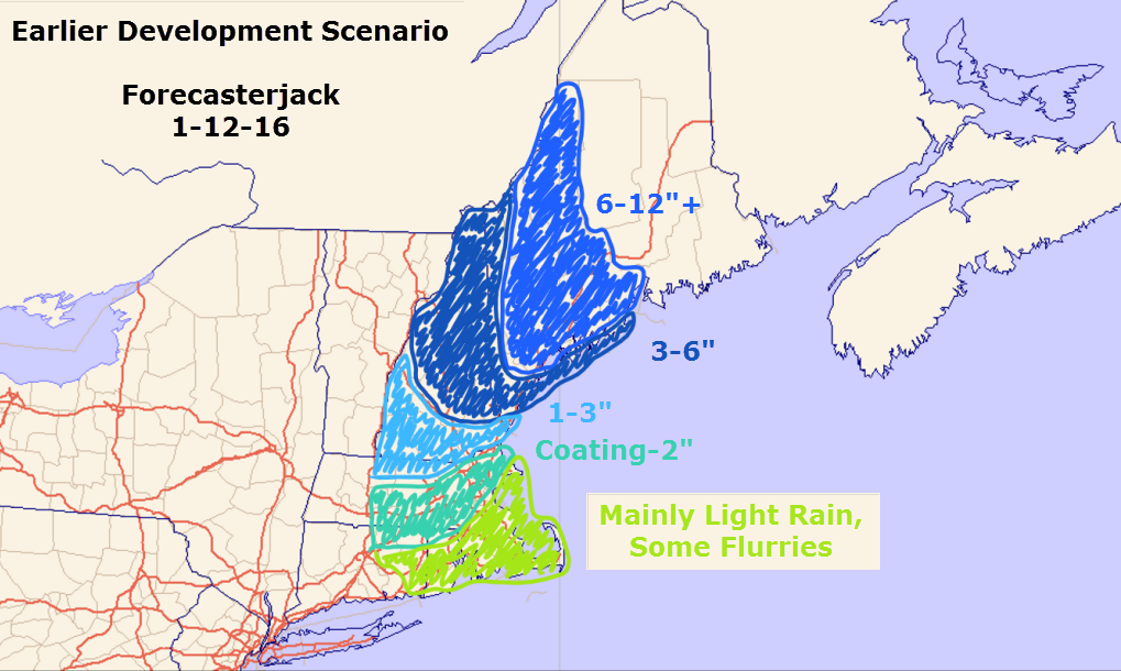
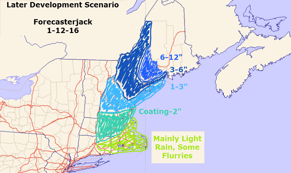
Here are my thoughts for snow. This is tentative as Norlun troughs are notoriously fickle. I’ll have another update tomorrow morning.

-Jack

A Messy Storm Today

Hello everyone!

Today will feature mainly awful weather conditions with a mix of snow, sleet, and freezing rain with a hint of normal rain along the immediate coast. Temps are already beginning to crash as winds are turning northerly and moving cold air in. Expect to change over to snow in the next couple hours even at the coast. Heavier bands are moving in from the ocean but I have questions as to how far they make it. I expect snow totals to come in on the lower side today for most especially inland. The trend overnight has been towards slightly less total precip. Not a complete forecast bust but don’t be surprised to see a tad less than expected. Freezing rain will be another threat along the coast as temps at the surface remain steadfastly below freezing while temps aloft still have a bit of cooling to do. We already have a solid glaze at the coast and as snow falls on top of a layer of ice on top of ice leftover from our last storm, expect extremely slippery roads and sidewalks. Temps will be falling  through the 20’s today as cold air moves in.

-Jack

A Messy Storm Arrives Tonight, Lasts Into Tomorrow

Hello everyone!

We’re still on track to receive a sizeable storm tomorrow as low pressure moves up the coast. The trends this afternoon have been towards low pressure being slightly farther east which would mean slightly cooler temps along with slightly less total precip. Overall, this leads to little shift in terms of how I think things play out but there are a few important differences. These differences mainly revolve around how things play out at the coast and just inland.2016-01-15_16-05-03

Looking at observations this evening, the forecast mainly looks good. A coastal front is forming across York County and will continue to sharpen up as low pressure develops offshore. The GFS shows this well. Keep in mind, models have had a very difficult time with this storm so don’t take any of the model graphics I post verbatim. They’re just to illustrate an idea not an exact figure or forecast.

Temps on the warm side of the coastal front are already above freezing over Coastal York county. Winds are off the water there and thus temps will continue to rise through the evening. Wherever that sets up, look for rain on the SE side and snow/freezing rain on the NW side. As always, snow amounts could be bumped up a few miles NW of the front as clashing warm and cold air will increase lift/forcing.

gfs---nepoolnerc-48-C-fronto850
12Z GFS Showing Modest Forcing For Heavy Precip Tomorrow Morning. Credit: Accuweather

While dynamics don’t look crazy for this event, there is modest forcing for heavy precip tomorrow morning through midday. As this map shows, bands are likely to extend well into the mountains. Don’t worry at the coast, precip will be moderate to heavy there too but driven by different factors. The heavy precip will assist in dynamic cooling which will further assist cold air in moving southward tomorrow midday. I think everyone sees accumulating snow tomorrow afternoon/evening even areas that see rain for most of the event.

2016-01-15_6-07-03

I’m sticking with my snow map for now as I don’t have the flexibility for adjustments and it still looks good. The jackpot will fall in the southern mountains and northern foothills with lesser amounts north and south. The one area to watch for higher amounts will be the southern end of things towards the coast. There is more liquid available at the coast but less cold air. If the cold air can show up, that extra QPF (Quantitative Precipitation Forecast) could allow for bust potential.

I’ll have updates when I can this evening on Twitter and another blog update will arrive tomorrow morning.

-Jack


Another, Messier Storm Arrives Saturday

Hello everyone!

It looks like we’re heading into a more active period of weather and our next storm is lined up for Saturday. While this one does look to pass well offshore, that doesn’t mean we’re out of the woods for mixed precip. Let’s break it down.

Setup

12Z GFS Showing The Setup Saturday Morning. Image Credit: Weatherbell

As with most winter forecasts, there are factors for and against snow. There are some indications that some weak Cold Air Damming could form but there is no big high pressure to the north. The stronger low will rapidly intensify to our east but it takes a while for the western low to decay. Before it does, it will try really hard to pull warm marine air northward. By default, it takes a heck of a lot to drag a warm airmass inland very far inland over cold air with a fresh coat of snow. Right now, I doubt rain moves much farther inland than I-95/I-295. It will take a bit more to convince me a weakening low over southern Ontario can accomplish significant warming.

Snow/Rain

Screenshot (12)

Precip arrives tomorrow night first in the form of light snow in the evening. Warm air will be moving in from offshore and will rise up and over the existing cold air. Snow remains mainly light until Saturday morning when the low gets closer. At this time, it looks like most areas see snow with the coast at risk of rain. At this time, it looks like some low level warmth makes it a few miles inland just above the surface where Cold Air Damming has less of an effect. Should this occur, sleet and or freezing rain could present issues mainly in the area outlined in Purple. Keep in mind, areas south of the current heavy snow area have a legitimate shot at seeing more snow. Experience has taught me never to underestimate cold air in Maine in January. Looking for proof? Remember Tuesday night.

Everyone changes back to snow Saturday evening as cold air blasts south behind the developing storm. Cold air follows for Sunday before more snow arrives Monday. It looks like this could be a Norlun type setup so details will have to wait until Sunday.

I’ll do my very best to get an update up tomorrow afternoon but my school obligations are stacked against me. I’ll be at the indoor track meet at USM for most of the later evening following a team dinner earlier in the evening.

Regardless, I’ll have updated details tomorrow morning and Saturday morning.

-Jack

A Calmer Day Today

Hello everyone!

Today will feature mainly sunny skies, light winds, and cool temps. Look for highs ranging through the 20’s throughout the area. There may be a flurry or two especially across the mountains but nothing major is expected.

Our next chance for precip arrives over the weekend but the details remain very uncertain.

-Jack

Turning Colder And Windier Today

Hello everyone!

Today will feature snow moving out, the main band that brought thundersnow to the Portland area last night is now long gone NE of Bangor and just snow showers remain. There’s currently one moving through Cumberland County and currently one near Augusta as of 5:15. These will continue through mid morning before dissipating and moving offshore. An additional coating to an inch is possible.

Winds will be picking up today as cold air moves in. Look for gusts up to 40 mph along with blowing and drifting snow. Temps are starting the day in the 20’s and will remain there through the afternoon as colder air moving in counteracts the heating effect of the sun. As the sun goes down though look for rapidly dropping temps.

All in all, a pretty wintry day for Maine, something we haven’t seen much of this winter.

Our next chance for significant snow could arrive over the weekend.

-Jack

Intense But Brief Snow Tonight

Hello everyone!

Not a lot has changed from this morning in regards to tonight’s forecast. Snow is ongoing across the area now but big accumulations will hold off until after around 9 PM when a very heavy band looks to sweep NE. As it does so, it will be intensifying and slowing down.

HRRR Model Showing Intense Snow Sweeping NE This Evening. Credit: Weatherbell

The farther NE you go, the heavier the band will be and the longer it will last. In this band, look for very intense snowfall rates of 2-4″ per hour along with gusty winds and potentially thunder. It won’t last terribly long for most, maybe an hour or two, but in that time, the snow will really pile up. If you are driving late tonight look for very dangerous driving conditions with near whiteout conditions. Thankfully, the worst of the storm will be from 9PM to around midnight. After that, the snow abruptly shuts off and NW winds pick up. Some snow showers could linger through tomorrow morning especially in the mountains and NE.

Screenshot (10)

I still like my snow map from this morning. Remember, most of this falls in just a few hours late tonight. It will be quite a show if you happen to be awake for it!

Be careful tomorrow as winds will be gusting near 45mph which will blow around the new snow. The greatest threat for reduced visibility due to blowing snow is inland where the snow will be fluffier.

Initially there were concerns about coastal mixing and that is still possible but observations show cold air hanging tough for everyone but the outer peninsulas. Should this change between now and when the heavy band blasts through, areas east of Route 1 could see reduced accumulations.

Believe it or not, we got another storm lined up! More snow, possibly significant, could arrive Saturday. There are significant questions so the details will have to wait a while but know the potential is definitely there! Welcome to winter the way it should be!

-Jack

A Dynamic And Intense Storm Arrives This Evening

Hello everyone!

A jucier than normal morning post today as the forecast for this evening is fascinating and very complicated. Before the snow arrives, look for increasing clouds with highs in the 20’s inland, low 30’s along the coast. Snow should arrive around 4 PM or a little after, then things get interesting.

0Z GEM Showing The Setup. Image Credit: Weatherbell

The setup from yesterday evening’s post remains largely the same this morning. Low pressure currently over Michigan will move E into southern Ontario this afternoon. Secondary low pressure will develop to our SW and move NE east of us. How fast this low develops is the key to the forecast. The general idea is that the combination of tons of upper level energy, warm ocean waters, and a favorable upper level setup (VERY negatively tilted trough for those that understand) will lead to rapid development just offshore.

0Z GEM Showing Intense Banding Across Western Maine Tonight. Credit: Accuweather

Intense snow bands will begin to develop along with the low but when and thus where these bands develop is still an unknown. We do now have a slightly better idea of where to look for the heaviest snow, the lightest snow, and where it could go either way. This is a very complicated situation and I mean it when I say there is high bust potential here. With that being said, I doubt York County sees much more than 2-4 or maybe 5″. It looks like things pull together just a little too late down there. The Midcoast and areas NE of Augusta/Auburn are likely to see a solid 6-10/8-12″ snow. It’s the areas in between that are really tricky.

Screenshot (10)

This is what I anticipate snow amounts to look like. Uncertainty is very high especially NE of York County and SE of Augusta.

Even in areas without much accumulation in terms of raw numbers, expect difficult travel as the snow will fall very heavily. There is also the chance that those in the heaviest bands see thundersnow this evening as well.

The immediate coast could mix with rain this evening before the heaviest stuff arrives. If this happens, watch for a rapid refreeze which would cause dangerous travel in those areas. Right now I think the peninsulas are most at risk for this but anyone east of Route 1 should be watchful.

Snow moves out tonight leaving a cold and gusty wind for tomorrow.

I’ll have another update tonight.

-Jack

Highly Uncertain Snow Event Tomorrow Night

Hello everyone!

My apologies on this post for an uncertain snow event going out so late and being so short, cramming in something that usually takes 4+ hours into 2 is hard. With that aside, I’ll do my very best to look at the forecast for tomorrow night in some detail below.

Overview

12Z GEM Showing The Setup Tuesday Evening. Image Credit: Weatherbell

A clipper system is currently moving across Minnesota and will continue to dive SE tonight into tomorrow morning. It will end up over the Eastern Great Lakes by tomorrow afternoon. At this time, a new low will form near NYC/Long Island and move NE as it strengthens. The key to this forecast and why it is so uncertain is how fast this low intensifies. I want to stress that the difference between a widespread 3-6″ and a widespread 8-12″ event is a few hours. If the storm forms a bit earlier, there is more snow. If it is a bit late, there is less snow. Either way, a burst of heavy snow is likely tomorrow evening around or a little after the evening commute. Overall, impacts should be minor but after 7 or 8 tomorrow evening, roads are likely to become quite slick.

The Earlier Development Scenario

12Z GEM Showing Intense Upward Motion Leading To Very Heavy Snow Over Western Maine Tomorrow Night. Notice The Position Of The Red (Very Heavy Snow) Over Western Areas. Credit: Accuweather

This is the GEM model showing the earlier development scenario. At 11PM tomorrow night, an intense band of very heavy snow is located over Western Maine centered on a Portland-Lewiston line. In this scenario, intense snow bands develop earlier and farther to the west leading to higher totals across SW areas. Based on very warm SST’s offshore and the very high amount of energy blasting SE with the clipper, I think this is the more likely scenario. The 500mb trough will also be going sharply negative.

12Z GEM Showing The 500mb Factors In Favor Of Explosive Storm Development. Image Credit: Accuweather

A very negative trough with a ton of energy blasting over record warm ocean temps is a setup ripe for explosive storm development.  The 12Z GEM shows this well. The other models show a similar setup and the GEM has shown itself to be very reliable when dealing with clippers and Canadian airmasses. It was the one model that caught the surprise no-show of the February 15 blizzard and I think it is on to something in terms of surprises with this storm. 2016-01-11_18-09-09

This is what snow totals would look like if the low developed on the early side. Consider this my forecast.

The Late Development Scenario

12Z GFS Showing Snow Bands Firing Up More Along The Midcoast Than The ME-NH Border. Credit: Accuweather

It is also entirely possible things don’t pull together in time and the heavy snow bands really get going more over the eastern Midcoast than the NH-ME line. The GFS shows this well. This is the same parameter (upward motion) for the same time as the GEM map posted above. Compare them and look at how much farther NE the heavy snow bands (bright colors) are on the GFS compared to the GEM. This is the difference between 3″ and 8″ for most areas SW of Augusta. Where these snow bands set up is the entire forecast at this point. It is important to note that the GFS shows nearly the same 500mb setup. The trough on the GFS is the exact same as on the GEM with the only difference being the GFS is 30 or so miles farther NE. That is the difference between 3″ and 8″. I really want to stress how tiny the differences are in terms of the science. 30 miles is a tiny margin of error, it just so happens that this time that margin of error has tremendous impacts for a large swath of the area. Be prepared for either scenario despite the forecast being for more snow.

2016-01-11_17-52-11 This is what snow totals would likely look like given the late development scenario playing out. This is not what I expect to happen but it remains a viable solution. In fact, new clues have emerged since the making of this map that indicate that totals could be slightly less than this if the low really fails to get going. Don’t be shocked if you wake up Wednesday to only a few inches SW of Augusta. Several inches look like a safe bet for the Midcoast and the NE mountains.

Coastal Mixing Concerns

12Z GEM Showing Near Freezing Temps At The Coast. Credit: Weatherbell

Winds ahead of the clipper will be onshore and thus temps will be marginal at the coast. However, winds will turn N/NE as the coastal low develops which will act to shut off the source of warm air. Also, heavy precip acts to cool the air and precip will certainly be heavy tomorrow night. All added up, I think this will be a wet snow for most coastal areas with only the peninsulas seeing rain. Again, this part of the forecast depends on the coastal low. The faster the low develops the faster cold air rushes in.

This is a VERY uncertain forecast so I’ll try to have an in-depth update tomorrow morning with details. I’ll have another update tomorrow evening as the storm is beginning. At this point, the details will be more clear (helpful, I know!).

-Jack

Windy And Cooler Today

Hello everyone!

Today will feature mainly sunny skies, cooler temps, and gusty winds as colder air moves in on the back side of our storm from yesterday. Highs already occured at 12:01 this morning and temps will be dropping from the 20’s and 30’s this morning to 10’s and 20’s by this evening. Winds could gust over 30mph which could cause another power outage or two and will also lead to wind chills dropping to near zero in the north by sundown.

-Jack