I’m a third-year atmospheric science student at Cornell University who has been blogging about the weather since 2011. While I’m not officially a meteorologist, I have accumulated a bit of experience forecasting both local weather (in western Maine and New Hampshire) as well as national/international weather during my time writing for weather.us and weathermodels.com. I also have experience programming in Python, teaching concepts in weather forecasting, and communicating forecast information to general audiences.
Today will feature continued quiet weather across the region as our pesky ocean storm drifts ever so slowly farther east. The storm is still responsible for some cloudiness and a few showers/flurries over the region this morning. While the latter should dissipate within the next couple hours, the former are likely to stick around a bit longer. Gradually though, breaks of sun should start to develop from west to east this afternoon. The increased sunshine combined with downsloping from light northwesterly flow will push temps into the mid/upper 30s along the coastal plain this afternoon. Up in the mountains, some residual upsloping and closer proximity to colder air will limit temps to near 30.
Today will feature generally cloudy skies and generally calm weather as the ocean storm we’ve been dealing with for several days continues to spin just off to our east. Morning breaks of sun are likely to give way to overcast skies by this afternoon as the storm sends another surge of moisture in our direction. This surge may be just enough to touch off some flurries over the Midcoast and adjacent parts of the I-95 corridor but accumulations should be limited to a dusting at best. High temps today will range from the mid 20s up north to the mid 30s in southern NH.
Today’s weather will be determined mostly by the whims of a powerful ocean storm sitting several hundred miles southeast of the area. This was the storm that we were watching last week for the potential to be a major blizzard. Sadly the ingredients just didn’t come together perfectly this time around but we’re still just close enough to get some light precip as the storm retrogrades into the Gulf of Maine.
Observations and radar imagery this morning show a couple bands of light to perhaps even moderate snow moving from east to west across the area. Between these bands, there isn’t enough upward motion in the atmosphere to produce snowflakes so precipitation is falling as drizzle which, given temps below freezing, will freeze on contact with objects and surfaces. This general pattern seems to be the one which we’ll enjoy for most of the day as the ocean storm completes its loop well to our southeast. Spots that see the most persistent light/moderate snow could end up with 2-4″ while the rest of the area sees a dusting to perhaps an inch or two.
Honestly, the snowfall map I posted back on Sunday, while perhaps a little bullish near/west of Portland and a little bearish up in the mountains near Sugarloaf still doesn’t look so bad this morning.
Most of NH already picked up their dusting-2″ in the first phase of the storm Sunday night so what’s left for today is mostly in Maine. The best shot at seeing over 2″ would be north of Route 1 and along/east of I-95 in the interior Midcoast. Either way, the snow and freezing drizzle will produce some slick spots on the roads so take it slow if you’re headed out and about.
High temps today will be fairly close to where they are now (upper 20s north, low 30s south) as overcast skies limit the amount of solar heating we can generate and neither warm nor cold air is being pushed in our direction by the wind. The best chance for some sunny breaks would be over in central/western NH.
Today will feature mostly cloudy skies and generally quiet weather as a strong area of low pressure spins just a little too far southeast for us to cash in on its heavy precipitation. Some flurries are noted on radar imagery this morning but overall most should stay dry today. If you do get snow, it shouldn’t accumulate much if any. High temps will be seasonably mild, ranging from the low 30s in the north to the mid 30s along the coast. The best chance for some sunshine today will be over northern and western NH.
While we’re not even 24 hours removed from our most recent winter storm, we’re less than 24 hours away from kicking off the next one. Today will feature mostly quiet weather ahead of that next storm.
Satellite imagery this morning shows a couple breaks of clear skies especially southeast of the mountains in Maine. Whatever glimpse you get of the sun this morning will be short-lived as clouds push into the region from the southwest ahead of the next storm. Those clouds will help keep temps in check today despite relatively warm air aloft. Highs look to range from the upper 20s north to the mid 30s along the NH Seacoast.
By this evening, light snow will break out in NH and adjacent parts of southwestern ME as shown by the darker blue shading on this forecast map valid at 8 PM.
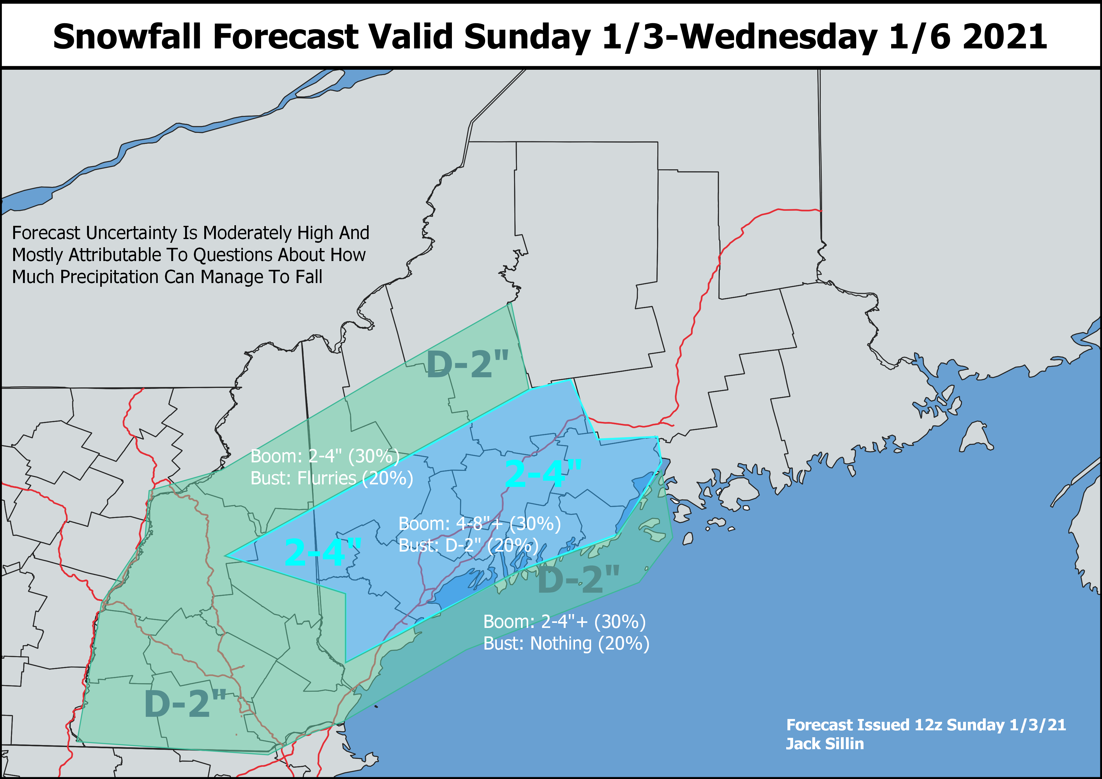
The big question then becomes: just how much snow is this storm going to drop? This question has been frustratingly hard to answer over the past couple days.
The central problem is that unlike most of our storms here in New England, this one appears likely to hit the brakes just east of Cape Cod and basically sit still for a couple days. Where exactly the storm decides to camp out will determine whether parts of our area get a couple inches or a couple feet of snow.
This loop shows that “stalling” process with bands of heavy precipitation lurking just northwest of the low’s center. Right now, most forecast model guidance suggests that these heavier bands will stay just offshore. This would keep snowfall totals fairly modest especially in the foothills/mountains. However, a wobble 50-75miles northwest would mean that instead of lingering over the ocean, these heavy bands could linger onshore and drop substantial totals.
Given all that uncertainty, it’s tempting to kick the can down the road a little more on a snowmap but since flakes start to fly in less than 12 hours now, it’s time to offer a first guess.
The highest totals I think will be found in interior parts of the Midcoast where I bet we’ll see plenty of 4,5, and 6″ reports. Confidence wasn’t quite high enough to include a 4-8″ contour but I was pretty tempted between Augusta/Waterville, and Camden/Belfast. Otherwise, there are some solid hints of a band setting up from the Whites through the ME foothills so I tried to reflect that in the 2-4″ contour. Surface temps will be right around freezing for most of this event which means that accumulation will be tough and heavily dependent on precipitation intensity right at the shoreline.
I’ll be following along with today’s forecast data closely and if any substantial changes to the forecast are needed, I’ll do another update this evening. Otherwise, let the light flakes fly this evening and revisit in the morning once we move into the stall/pivot phase of the system.
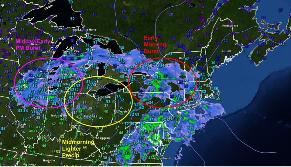
The winter storm discussed in last night’s post is well underway this morning and overall the forecast is holding up well. The lull in precipitation expected in southern areas midmorning has arrived while our next round of heavier stuff sits back to the west over Vermont. As expected, snow is falling in the mountains and most of the foothills while sleet/ice has mixed in over southern NH and far SW ME. Right along the coast, temps have warmed into the mid 30s and as a result, precipitation has gone over to rain.
Expect sleet/ice/rain to change back over to snow around lunchtime for all but coastal York County, southern NH, and perhaps the Midcoast peninsulas. Not much more accumulation is expected along the coast given relatively mild temps, but several more inches will fall in the colder air inland.
So far, snowfall totals are coming in right around what was expected.
Precipitation will depart the region from SW to NE this afternoon as NW breezes pick up. Temps will stay pretty close to where they are now for most of the day before dropping into the 20s tonight.
Quick evening update here to outline tomorrow’s storm in a bit more detail before it gets underway.
The bottom line is that a mid-grade winter storm is headed towards the region tonight and will arrive with a burst of moderate to possibly heavy snow early tomorrow morning. Snow will mix with some sleet and rain in southern/coastal areas later tomorrow morning before a final burst of snow throughout most of the region early tomorrow afternoon. If you’re curious about more of the details, read on!
Radar imagery this evening shows the elongated structure of our incoming storm. The system is moving in from the west-southwest, so we can draw a line in that direction and get a pretty good sense of what the forecast might entail for the next 24 hours. We’ll start off with a solid burst of snow in the early morning hours before the lull in precip currently over Ohio arrives. The storm will then wrap up with the burst of heavier precip currently near Chicago.
The little numbers on the map above are current (7 PM EDT) temperatures. Note that most of our area is near or, in the case of Manchester NH, a little above freezing. This means that we’ll have to worry a bit about precipitation types.
The forecast map below shows a bunch of information useful for thinking about the storm. We’ll start with the shadings which depict temperature (see the scale at the bottom of the image) and precipitation type (blue = snow, orange = sleet, pink = ice, green = rain).
The mountains will hold onto enough cold air to keep this one all snow. Far southeastern NH is already above freezing and will remain that way through most of the event, so I’m expecting mostly rain there (except for a quick burst of early morning snow). It’s the in-between spots that will be trouble. Right now, it looks like warm air aloft will make it as far north as the White Mountains in NH and about Lewiston/Augusta in Maine. That means that snow will change over to sleet and/or ice (sleet is more likely in Maine and central NH, ice is more likely in southwestern NH).
Right along the immediate coast east of I-95/I-295 and south of Route 1, surface temps may warm up just enough for some mixing with plain rain.
Around 8-9 AM or so, we’ll start to see the lull build in as the original storm fizzles out and a new one takes its place east of Cape Ann.
The lull will be most pronounced in southern areas where a mix of sleet/rain will give way to drizzle/freezing drizzle. Moderate snow should continue in the mountains as cold air begins to slowly drain south on the back side of the coastal low.
This storm’s final act will come as that coastal low starts developing in the Gulf of Maine, bringing one last burst of moderate/heavy snow to most of the area (except perhaps the coast south of Portland) before precip wraps up during the mid/late afternoon.
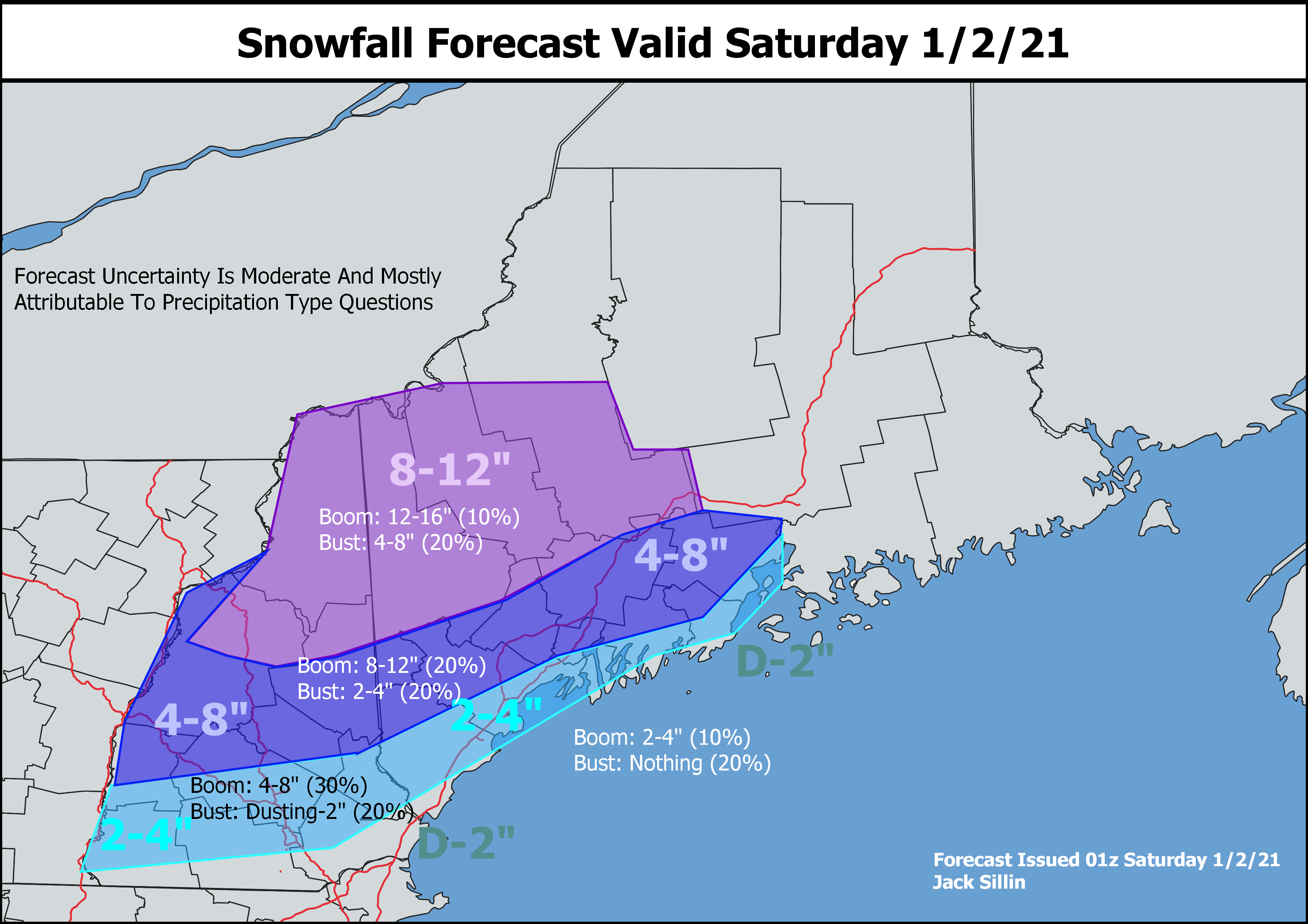
Here’s a look at how much snow I think should fall across the area tomorrow. The jackpot will be up in the mountains where 8-12″ of pure snow should pile up. Amounts drop off as you head closer to the coastline and farther south where rain and sleet/ice will mix in.
Make sure as you’re cleaning up tomorrow afternoon to leave plenty of room for more snow. More is likely to arrive as soon as Sunday night, and there could be quite a bit for some!
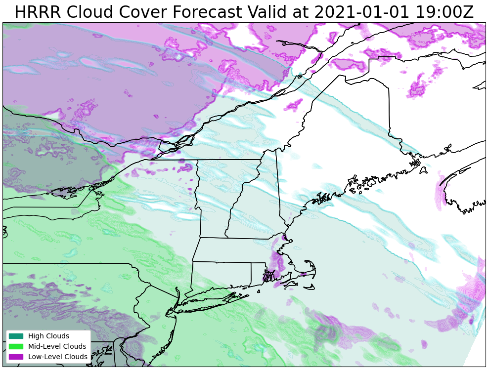
Today will feature quiet weather as high pressure slides overhead out in front of our next storm system currently spinning over the Plains. Skies will start off mostly sunny this morning before high clouds gradually filter in from the west this afternoon.
This forecast map shows cloud cover expected around 3 PM, and the blueish hues suggest high “cirrus” clouds moving in ahead of the thicker mid-level clouds denoted in green.
High temps today will range from the mid 20s up north to the mid 30s in southern NH.
Our next storm system will arrive from the west tomorrow with an early-morning burst of snow across the area giving way to more snow in the foothills/mountains while southern areas and the coastal plain deal with a mix of snow, sleet, freezing rain, and plain old rain.
I’ll try to have another update up this evening focused on this system. Right now, it looks like 8-12″ is possible in the mountains with a general 4-8″ north of Plymouth NH-Brunswick-Belfast and 2-4″ along the coast/south of that line.
Today will feature the return of mostly cloudy skies as our next system approaches from the west. Morning breaks of sun especially in NH will fade as the day progresses with the entire area under a layer of thick clouds by the end of the day. The storm of interest for the next 24 hours or so will be passing to our west meaning that we’re on the warm side. Thus temps will rise steadily today from the 10s this morning to the upper 20s north and mid 30s south by this afternoon.
Some snow flurries will begin developing over the north and mountains this afternoon/evening, but most precip should hold off until the overnight hours. Precip will fall mostly in the form of snow up north (1-3″), an icy mix in the foothills (watch for some slick spots on the roads), and rain along the coast. By tomorrow morning, this system will be on its way out and cooler air will once again be pushing into the region from the northwest.
Today will feature cooling temps and generally clear skies as high pressure moves in from the west. Winds this morning are from the northwest, a pattern that will continue through much of the day. That means we’re starting out with some upslope clouds and flurries up in the mountains. As drier air continues to push into the region this afternoon, these clouds should thin and clear out. Temps will drop steadily from where they are now in the mid 20s north/low 30s south to the mid 10s north/mid 20s south by this evening.