I’m a third-year atmospheric science student at Cornell University who has been blogging about the weather since 2011. While I’m not officially a meteorologist, I have accumulated a bit of experience forecasting both local weather (in western Maine and New Hampshire) as well as national/international weather during my time writing for weather.us and weathermodels.com. I also have experience programming in Python, teaching concepts in weather forecasting, and communicating forecast information to general audiences.
Today will feature increasing clouds as another cold front moves in from the west. Out ahead of it, we get one more day of mild temps with highs up north getting into the upper 30’s to low 40’s and temps in the south getting into the low 50’s for many. The cold front passes without much incident this evening though a few mountain flurries are possible.
Our storm this upcoming week is still on track but just because we’re getting closer to the event doesn’t mean we’re all that much closer to deciphering what will happen. The trend in guidance over the past 24 hours has been towards a warmer solution with brief snow quickly going over to rain. While this remains very much a viable solution, I’m not ready to bite just yet. I want to wait for a few more rounds of guidance with better sampling of the disturbances that will eventually form the storm before I pull the trigger on a rainy solution. Due to that, my thoughts haven’t changed much. A cold front will move through tomorrow night and colder air will follow for Monday. Low pressure will then move NE from the Gulf of Mexico. Its exact track will determine what falls from the sky. We should have a better idea Monday afternoon as the disturbances that will form the storm begin to join together over Texas.
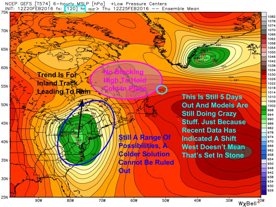
12Z GEFS Showing Uncertainty In The Forecast For Next Week. Image Credit; Weatherbell
Here are the GFS ensembles for the storm. While there is still a large spread in ideas as to where the storm will track, guidance is converging on an inland track. Notice the lack of a large high to the NE to feed cold air into the region. Our cold high from Monday has already been swept off to the Azores which leaves warm air free to flood northward. While I’m still not completely convinced, this is the solution I’m leaning towards based on the pattern and what I’m seeing in terms of guidance.
Following this storm, colder air moves in for the weekend and we have another shot at snow around that time as well.
Today will feature mainly cloudy skies along with off and on rain and snow showers as a warm front moves through. Look for another inch or so of accumulation up north with just light rain showers in the south before things dry up this afternoon. Highs will range from the low to mid 30’s north to the mid to upper 40’s south. Some sun is possible this afternoon especially SW.
Our pattern slowly becomes more active over the coming week beginning with light snow tonight and ending with what could be a large storm next week. We still have three storm threats but I don’t think Northern New England gets much of anything with the Monday storm threat I talked about a couple of nights ago. However, that storm still plays an important part in the lead up to what has the potential to be a large storm next week. For now, let’s look at tonight and the storm expected to drop light snow in the next 12-18 hours.
Radar/Surface Obs Composite From ~5:00PM This Evening. Image Credit: COD
Light precip is falling over NY currently and this will move east into our area tonight. The low pressure responsible is tracking to the north and thus is dragging warm air up into the region on southerly winds. This will be enough to result in a wet snow for the mountains and foothills and wet snow mixing with rain along the coast. Snow will fall predominantly tonight into tomorrow morning and will be largely in the form of snow showers with on and off precip. Little accumulation is expected and my original thinking of 2-4″ for the mountains, 1-3″ for the foothills, and a coating-2″ for the coast/coastal plain looks good. Warmer air will flood into the region behind this storm on westerly winds setting up spring like temps this weekend. Highs tomorrow will be in the 30’s and 40’s following precip clearing out in the morning. Highs Sunday will get close to 50 in the south with 40’s for most.
18Z NAM Showing The Setup Monday As Cold Air Builds. Image Credit: Accuweather
A cold front sweeps the warmth offshore Sunday night and low pressure develops along the front Monday. This will remain largely to our south though more clouds are likely for all with a flurry possible in the south. The big impact though will be the cold building in with a fresh Canadian airmass sweeping SE. By the time Tuesday rolls around, we will have a stalwart 1030mb+ high that won’t be in a hurry to move. This sets up our midweek storm threat.
By the time next week arrives, a large and fairly deep trough will be carved out across the east with a ridge in the west. Tons of disturbances will be zooming around the east and the exact track of the storm(s) will depend on the exact strength/placement of each and every one of the disturbances I circled in blue (along with others not visible in this image). This is why this forecast is so darn complicated. Despite that, I think we can begin to make some sort of sense out of at least the basics. It is far too early to talk precip type or exact timing but I think the storm works in two parts. The first arrives at some point Tuesday or Wednesday and remains moderate or weak in strength. It looks to deliver moderate to light precip of some sort depending on the track. Remember, we have fresh cold in place so my inclination would be to lean towards less, colder precip as the low slides south. The second part of the storm arrives later in the week, Wednesday into Thursday and is much stronger. It could deliver much more precip depending on the track. Of what nature the precip is and exactly when it comes and goes is anyone’s guess at this point but the takeaway is that it could be much stronger.
All in all, a more active pattern is shaping up for our area heading into next week. While the exact details are TBD, it does look like we have a good chance at seeing significant precip. Could it be mainly rain? Sure. Could it go out to sea? Possibly. Could it deliver significant frozen precip? Absolutely it could. Stay informed with the latest forecasts through your favorite source (NWS, local media, people like me) and remember that this is still very far away. Don’t panic, stay informed.
Today will feature increasing clouds as our first weak storm approaches from the west. Look for chilly temps near or just above zero this morning warming into the low to mid 20’s north and upper 20’s to low 30’s south. While clouds will be increasing, snow should hold off until later this evening.
Today will feature the passage of a weak cold front which will mean we run the risk of some flurries falling out of cloudy skies this morning. NW Winds will be noticeable but want be too bad. Highs will range from the low 20’s north to the low 30’s south. Cloudy skies this morning will give way to clearing by the afternoon.
As yesterday’s storm is now long gone, we are now settling into a quieter pattern in the immediate future. I’ll look at our quiet pattern with a few chances for precip and then I’ll outline the beginning of what could be an active pattern starting next week. Let’s start with these next few days.
Zonal Flow: Late Week Into The Weekend
12Z GFS Showing The Pattern Early Week. Image Credit: Accuweather
The rest of this week and into the weekend will feature flat, zonal flow aloft. You can see this in the image at left which shows westerly winds and lines of equal height (isopleths) more or less going from west to east. This type of pattern supports temps near or slightly above average and also keeps any storms weak. Two weak storms look to impact the area in the next five days, one Friday into Saturday and the other Sunday into Monday. They will be weak and will feature a mix of rain and snow depending on surface temps. Tomorrow will be a lot like today except maybe a tad cooler. Friday will feature increasing clouds and light snow in the afternoon while Saturday sees light rain/snow showers moving out. Sunday will see more clouds while snow arrives Sunday night and lasts into Monday morning. Amounts look light for both events. Sunday’s storm will set up a far different pattern aloft by early next week.
Meridional Flow: Next Week
12Z GFS Showing A Far Different Pattern Aloft Early Week. Image Credit: Accuweather
This is the same map as the one shown above but valid early next week as opposed to late this week. Notice the change in the winds and isopleths as well as the strength of the disturbances. This is the type of pattern needed for storms. Notice all the disturbances zooming around the eastern US. I’ve highlighted the strongest ones in blue. To actually get a big snowstorm, we need each of those disturbances in just the right place at just the right time. This pattern looks to continue trough next week with multiple threats for storms as different sets of disturbances attempt to consolidate into a larger storm. Is it possible that any one of those sets of disturbances does consolidate into a large storm that brings us significant snow? Absolutely. Is it likely? At this point, the odds are stacked against it as they almost always are this far out. The stage is set for a snowstorm but we need all the actors in the right place at the right time doing the right things for a good show.
Rarely will 40 sunny and calm feel as nice as today following one of the wilder roller coasters we have seen in a while. Look for clearing skies, gentle breezes, and temps in the 30’s north and 40’s south.
Some rain and snow is possible Saturday but no big storms are in sight until maybe early next week.
HRRR Giving An Idea Of What To Expect With Frozen Precip Tapering Off This Morning Then Heavy Rain Arriving This Afternoon. Credit: Weatherbell
Today will feature all four seasons as low pressure passes to our west. We’ll start with a slippery, wintry mess this morning as freezing rain and sleet fall on top of already fallen snow. Spring comes mid day as SE winds scour out the cold in place leading to warming temps. Some showers are possible in typical April fashion. Fast forward to July come evening as a line of heavy showers and thunderstorms approaches from the west. This line will mix down some of the 90kt+ winds a couple thousand feet above our heads leading to wind gusts along the coast of 50-60mph+. Winds gust through the night as fall arrives and temps gradually cool back to winter for tomorrow. I’ve covered each threat individually in my update last night so check there for the details. Do note however that my thinking for winds this afternoon has increased fairly significantly and power outages are likely with the ice still leftover from this morning combined with the strong winds will likely lead to downed trees/branches. This threat begins as winds start to crank mid afternoon and will wind down early tomorrow morning as the winds aloft move east. The greatest threat will be with the line of showers/thunderstorms this evening.
Snow is moving into Southern New England this evening ahead of our next storm and snow will move NE into our area tonight. Snow mixes with and changes to freezing rain tomorrow morning before a lull tomorrow afternoon. The lull ends with heavy rain and wind Tuesday evening before we clear out and cool down Wednesday morning.
First Round: Frozen Medly
Evening Radar Showing The Setup For Tomorrow. Image Credit: Accuweather
The general idea from Yesterday remains the same but with a few tweaks. Snow will move in from SW to NE this evening beginning around 7 in York County. Radar is indicating snow is falling across York County however with VERY dry air at the surface, I doubt this is making it to the ground. The ground is very cold and thus snow will accumulate quickly and efficiently once it starts falling.
Snow will fall throughout the night tonight and will accumulate to 1-3″ before warm air aloft begins to change snow to ice around or a little after midnight. Along the coast and across the coastal plain, this is all the snow you’ll get. For inland areas, another inch or two is likely bringing total snow to 2-4″. The mountains hold on to snow the longest with 3-6″ of accumulation. While the mid levels of the atmosphere get torched by a 50kt+ Low Level Jet, the air right near the surface will remain cold as cold dense air settles to the surface. For this reason, expect freezing rain to be the dominant precip type tomorrow morning with some sleet mixed in towards route 2. This will lead to a VERY slippery morning commute with roads a total mess due to several inches of snow under some sleet under a layer of freezing rain.
Second Round: Tropical Punch
18Z NAM Showing Very Strong Winds Aloft Tomorrow Evening. Image Credit: Accuweather
Freezing rain will continue through mid to late morning tomorrow before tapering to freezing rain showers as a dry slot briefly works in. During this time, the cold air will gradually be mixed out as southerly winds kick in. Precip will resume tomorrow evening as a cold front approaches. This round will be mainly rain except maybe for some isolated mountain valleys. Rain will be heavy at times and thunder is not out of the question as the cold front moves through. Winds will be gusty at this time as well with gusts over 40mph possible. Winds will be limited however by how much the cold air hangs on. The longer the cold hangs in, the more wind we see. Some power outages are possible during this time though significant impacts seem unlikely.
Rain moves out late tomorrow night with clearing and cooling expected Wednesday. More snow/rain is possible for Friday as a clipper system moves over the area.