Today will feature a break between yesterday’s fast-moving light snow event and tomorrow’s fast-moving light snow event. Between the two storms, a weak area of high pressure will nose into the region from the north. That means that winds will be from the northwest for much of the day, supporting clouds upslope of the mountains (especially this morning) and sunny skies for the foothills and coast. High temps will be on the cooler side as Canadian air works into the region, ranging from a little above 20 in the north to a little below 30 in the south.
Tomorrow’s light snow event appears to be focused more in the southern half of our area with a general 1-3″ expected. I’ll have another post out this evening taking a closer look at the system.
Today will feature the arrival of our next storm system from the southwest, a fast-moving coastal low that will bring light to moderate snow across the region today. Snow will start around or a little before noon in southern New Hampshire, around 1-2 PM in western parts of Maine, and around 2-3 PM for points farther northeast.
Before precipitation begins, skies will be mostly cloudy (except for some early breaks of sun in northern areas) and temps will rise into the upper 20s north and low to perhaps mid 30s in the south. Much like on Friday, temperatures will cool as precipitation begins to fall so outside a few stray raindrops right along the shoreline, this will be an all-snow affair. The map above shows expected conditions around 2 PM with snow falling across most of the area despite the freezing line (solid blue line) hung up in the foothills.
As we move into the afternoon, a band of moderate to heavy snow is likely to develop near the coastline. Rising air associated with this band will help boost snowfall rates up towards an inch or so per hour. What goes up must come down, and that means sinking air over the foothills and mountains which will see precip dry up during this time. Exactly where these bands of rising/sinking motion set up is more or less impossible to determine ahead of time, but will have a substantial influence on final storm totals.
This map shows the expected development of heavier snow closer to the coast and the end of snow inland around 5 PM. Also note that after a couple hours of precipitation, the freezing line has retreated to the shoreline.
Snow will rapidly depart to the east this evening as colder and drier air surges in from the northwest. On the leading edge of this new airmass, moisture from the Great Lakes and increased instability will likely support a few heavy snow showers/squalls. As per usual, these squalls will be most potent in the mountains but could bring one final coating to the coastline as well. Thankfully, the timing of these squalls between 10 PM and 1 AM is helpful for minimizing their impact to travel.
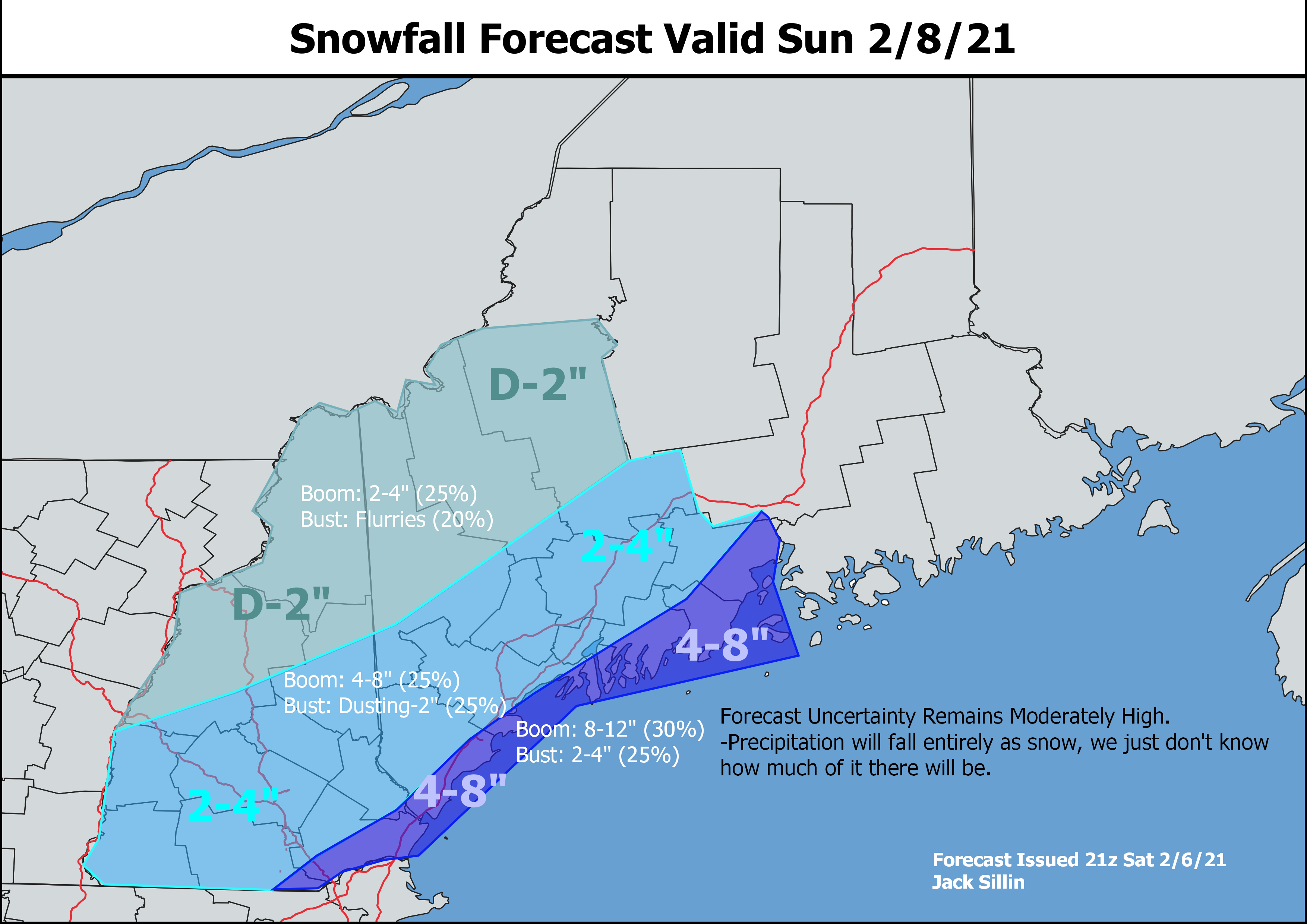
As far as snowfall totals go, here’s the same map I posted yesterday.
After looking at the latest information this morning, I think we’ll probably come in near the lower end of these ranges especially in southwestern NH. Right along the coast, 3-5″ reports will be more common than 6-8″ reports but I’m not willing to totally shut the door on some locally higher totals yet, as the possibility still exists for a mesoscale snow band to drift just far enough northwest to push a few spots towards 5-6″.
As a side note, I decided at the beginning of the winter to keep the same snowfall map ranges (2-4,4-8,8-12 etc) every storm for the sake of consistency and having a constant frame of reference. That’s why I’ve drawn 2-4″ and 4-8″ contours even though 1-3″ and 3-6″ would probably do a better job of capturing the most likely range of outcomes. Balancing the most helpful ranges for each individual storm with the benefits of consistency across the whole season is tricky, but hopefully this isn’t too far off.
We’ll get a day off tomorrow before our next storm moves in on Tuesday. That one also looks to be a light-moderate snow event, though it will include the mountains and foothills in addition to the coastline.
Maine and New Hampshire appear to have been put on the storm-every-two-days plan by Mother Nature to make back the snowfall deficits we opened up during our dry January. After snow Tuesday/Wednesday and Friday of this past week, we’re getting our day off today before flakes fly once again tomorrow.
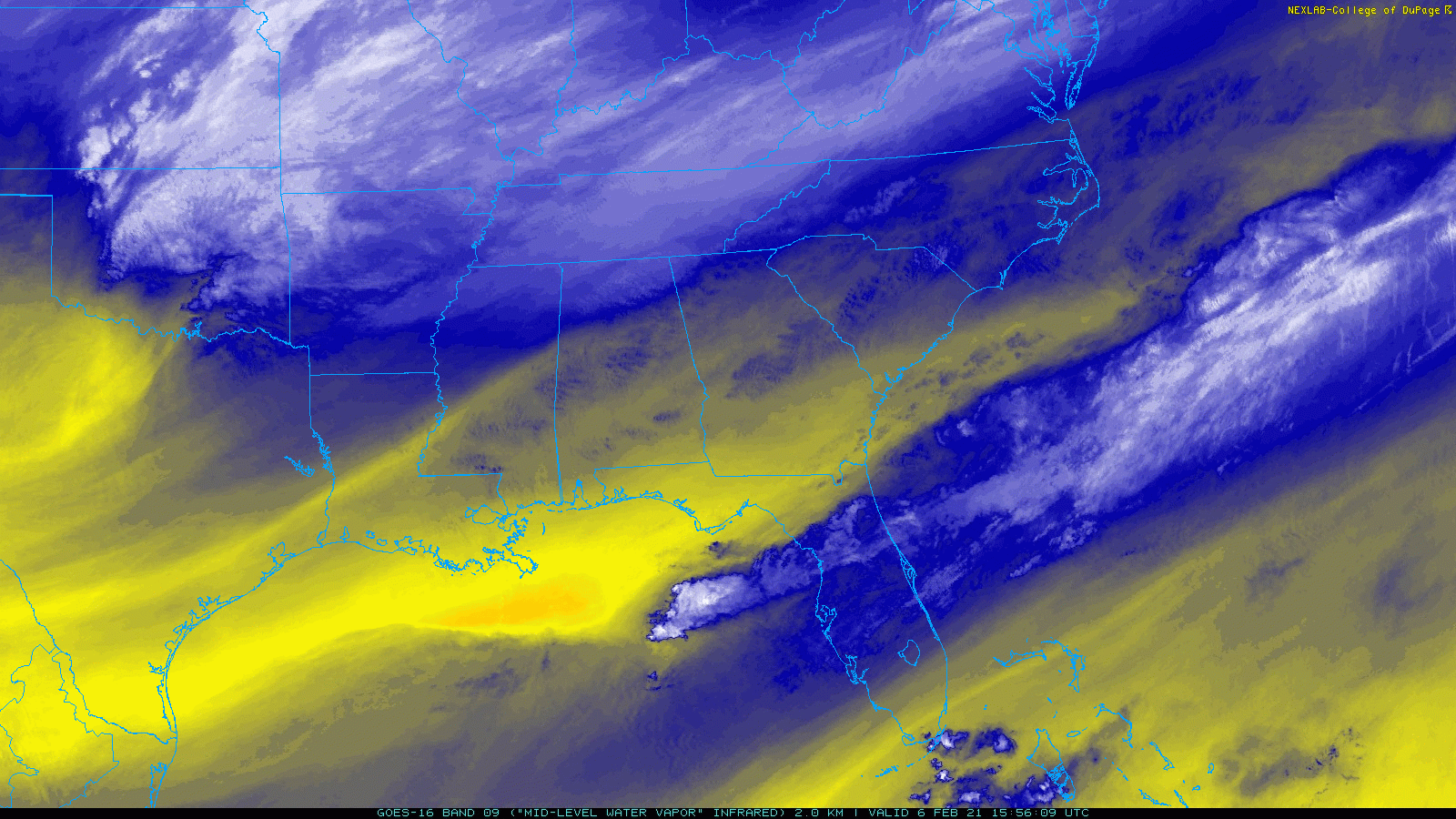
Tomorrow’s storm system is currently beginning its journey over the Southeastern states before it heads up the coast starting later tonight. The swirl over Oklahoma will become our primary storm system, and it will be steered in part by the thunderstorms visible over the Gulf of Mexico, Gulf Stream, and interior parts of AL/GA. Thunderstorms appear as blue/white speckles in the loop above.
These thunderstorms are a double-edged sword for our snowfall forecast. On the one hand, they can steer the storm farther northwest (closer to us) by releasing heat into the upper atmosphere as water vapor condenses and freezes. This would help push snowfall totals up a bit in our area. On the flip side, if too much water vapor condenses and freezes in these thunderstorms to our south, there will be less left over to move north and condense/freeze over our area tomorrow.
Whatever snow does make it up this way will arrive from southwest to northeast during the mid to late morning hours tomorrow.
While forecast model guidance continues to portray slightly different solutions in terms of how close the storm might track, I think the image above does a pretty good job highlighting what to expect tomorrow evening when the system will make its closest approach. Snow should overspread the whole area, though it will be rather light as you move closer to the mountains. Closer to the coast, moderate snow is expected with periods of heavy snow possible depending on exactly how mesoscale banding sets up.
Unlike our last system, this will be quite the fast-mover. While snow begins late morning or early afternoon for most, it will be all wrapped up by the fourth quarter of the big game.
Here’s a look at how much snow I’m expecting at the moment. While there aren’t any concerns with mixing this time around, there are concerns regarding how much precipitation actually makes it up our way. The highest totals will be found along and near the coast where 4-8″ is likely. I suspect we’ll probably see more 4-5″ reports than 7-8″ reports, but with the potential for mesoscale banding to significantly enhance snowfall rates, I thought it best to leave the door open on higher totals. This is also why the “boom” probabilities are relatively higher for this area. As we learned back in December, it doesn’t take that much of an adjustment in the location of a mesoscale snow band to produce significant adjustments in snowfall totals.
Snow totals will drop off as you head towards the mountains with the obvious caveat being west/northwest-facing slopes which should cash in on some substantial upsloping as colder air pours in behind the system tomorrow night.
After a string of mild days, cooler air is on its way back from Canada this morning. A weak front at the leading edge of the cooler air has scooped up some moisture from the Great Lakes and is helping some upslope snow showers stray into the foothills this morning. While some spots may see a few flakes, accumulations are not expected outside of the mountains where a coating-2″ will pile up today. Westerly breezes will help bring partial sunshine to the coastline while clouds hang tough up in the mountains. That breeze will also make forecast high temps in the mid 20s north to mid 30s south feel a bit chillier.
Enjoy today’s relatively nice weather as our next storm will arrive quickly tomorrow with a round of moderate snow.
Another storm is headed our way today as low pressure swings up through the Great Lakes. The storm’s track west of our region means that we’ll be on the warmer side, though a lucky quirk in the storm’s timing means it won’t be all rain. The system was far enough west last night that clear skies let temps cool off quite a bit into the 10s. Now, as the sun rises this morning, clouds are moving in which will limit how much temps can warm up. So while southerly winds off the water will boost temps into the mid 30s for most of the area by this afternoon, precipitation will fall as snow in the foothills and mountains with a mix of rain and snow along the coastal plain.
This forecast map shows expected conditions at noon today, by which point snow will be falling across most of the area. The freezing line is marked by the solid blue line, and points north of there have the best shot at accumulating snow, though flakes will fly farther south. The mountains can expect 1-3″ out of this system while the foothills get a dusting-2″ and the coast would be lucky to freshen up some of the dirty snowbanks.
Temps near/above freezing mean that road conditions shouldn’t be too bad today, especially outside the mountains but watch for slick spots when and where snow falls heavily. Improved snowfall rates can easily overcome marginal near-surface temperatures to produce accumulation, even on roads.
Rain and snow will depart from west to east this afternoon while another round of snow squalls approaches from Quebec. These squalls will pass through the region overnight so shouldn’t cause much disruption, but they may be able to drop another dusting to an inch especially up in the mountains.
High temps today will range from around 30 in the mountains to around 40 in southern NH.
Four days after the first clouds arrived from the last winter storm here in Maine and New Hampshire, snow is still falling across parts of the region this morning. While they won’t amount to much, flurries are being observed from Sugarloaf over towards Belfast this morning and may be able to freshen up the snowbanks a bit over the next few hours. Snow will depart this morning, but clouds will stick around for most of the day as this system is in absolutely no hurry to get out of here. The best chance for sunshine will be in NH and far western Maine during the mid/late afternoon hours. With no cold air to be found in the wake of this system, downsloping NW flow will support high temps ranging from the upper 20s up north to the upper 30s down along the coast.
Enjoy whatever sunshine you see this afternoon because another storm is on the way for tomorrow. It will bring light to moderate snow in the mountains and foothills with light rain expected along the coast.
Today will feature relatively mild temps and quieter weather as our storm slowly departs to the east. There’s not much cold behind this system so downsloping NW breezes will be able to boost temps quite a bit along the coastal plain. Highs there should get into the mid 30s. Farther north, cooler upslope flow will limit high temps to the mid/upper 20s up in the mountains. Despite the downsloping, skies will remain mostly cloudy as another batch of moisture pivots northwest off the ocean. At the moment, I don’t think that this moisture will make it to the ground outside the mountains but don’t be too surprised to see some flurries or sprinkles midmorning-early afternoon as it passes overhead. Up in the usual upslope spots, snow showers will continue for most of the day with an additional coating-2″ possible.
Snow is falling across much of the region this morning as low pressure stalls out near Long Island and tropical moisture is pulled north towards our area. Most spots have already picked up 6-10″ of snow from heavy banding overnight, and storm totals will likely increase a bit more today especially in the north and mountains.
The big question today is how much of the area gets impacted by another area of low pressure currently developing southeast of Cape Cod. Radar and satellite imagery show precipitation associated with this feature breaking out over the Gulf of Maine this morning, but it’s not clear how far west this precipitation will be able to push. At the moment, my best guess is that points east of a line from Portland to Paris will see another round of steadier/heavier precipitation today following the ongoing lull caused by some dry air aloft.
This next round of precip should begin between 9 and 10 this morning over the Midcoast before pushing north and west during the midday hours. For almost everyone, this new round of precip will fall as snow but some sleet is possible south and east of Route 1.
Meanwhile, heavy snow will continue to fall from the main band that has been impacting the area overnight. Currently, this band extends from near Conway NH through Paris over towards Farmington and Skowhegan. Snowfall rates of 1-2″ per hour will continue in this band as it lifts slowly northwest.
New snowfall today will range from a dusting to 1″ in southern NH to 12-15″ up in the mountains near Sugarloaf. Steady snow will become relegated to the usual upslope spots starting this afternoon as the best lift departs to the northeast.
Winds are breezy from the northeast this morning but will gradually taper off as the day goes on. High temps will range from the upper 20s up north to the mid 30s in southeastern NH.
Today will feature the arrival of a seasonably strong nor’easter bringing heavy snow, strong winds, and the possibility of some mixed precipitation.
Water Vapor satellite imagery leads the way as always this morning. The first swirl we were watching over the past few days is fizzling out over Ohio while the second is moving quickly east near the TN/NC border. As that second swirl meets up with the plume of deep moisture off the East Coast noted in green, the second phase of our storm will begin in earnest.
This second phase of the storm’s evolution will be part one here in Maine and New Hampshire (we missed out entirely on phase one yesterday over the Mid Atlantic).
Current observations as of 6 AM show seasonably cold temperatures across the region to start the day while snow is advancing slowly from the south.
Cold and calm will be the name of the game for the first part of the day as the storm gets its act together south of our area. Morning breaks of sun will be most common in northern and western parts of the area as clouds advance from the south and east. By late morning, ocean effect snow showers will be developing just offshore and will start to impact portions of the coast south of Portland. A dusting to 1″ is possible from ocean effect before the main storm begins after noon.
By 5PM, the time at which this map is valid, moderate to heavy snow will be underway across southern NH and southwestern ME while light snow starts to break out over central and northern areas. Because we’ve been enjoying such cold temps for the past few days, even the first few flakes will stick to the roads so conditions will go downhill not long after snow begins falling. Take it slow on the evening commute today if that’s still a thing for you, and use the storm as an excuse to duck out a few minutes early if you can.
The heart of the storm will arrive later this evening as the second swirl peaks in intensity south of Long Island. Heavy snow bands will pivot north through the region during this time, dropping snow at rates of 1-3″ per hour. Meanwhile, increasing northeasterly winds will lead to blowing and drifting of snow especially inland where temps will be cooler and the snow fluffier.
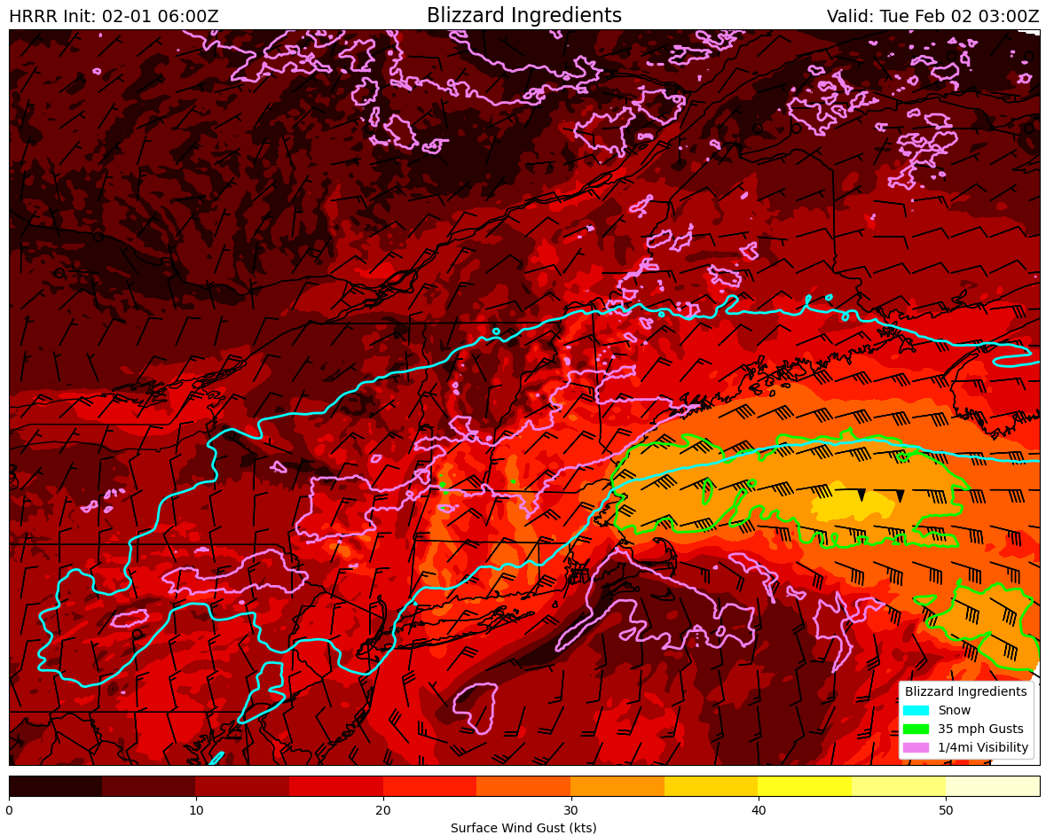
With gusty winds and heavy snow, will this storm qualify as a blizzard?
The answer comes down to whether three criteria can be met at any given place for three consecutive hours: visibility at or below 1/4mi, winds sustained or frequently gusting above 35mph, and heavy falling and/or blowing snow. The map above outlines where each of the three atmospheric conditions will be met at 10 this evening. If you’re in all three circles, congrats! You’re experiencing blizzard conditions!
Most of the region is in the blue circle meaning that snow is falling. Southern areas are inside the pink circle which means that visibility has been reduced to 1/4mi or less. But only some hilltops in southern NH and parts of the York County/NH coast are in the green circle with wind gusts over 35mph. So while travel conditions will be rather dangerous, we appear unlikely to meet the rigorous criteria to deem this officially a blizzard. It sure will feel like one though!
By tomorrow morning, the second swirl will begin weakening which means precip in our area will too. As warmer and drier air moves in around 10,000 feet, precipitation types will start changing too. Rain may mix in along the Midcoast peninsulas and east of the Turnpike south of Portland. Sleet will be a little more widespread especially east of the Turnpike north of Portland. Freezing drizzle will be more common as you move farther west as temperatures remain cold, but snowflake production gets interrupted. This will mark the end of the first round of substantial accumulations in Maine and New Hampshire.
At this point, about 6-10″ of snow should be on the ground with the most in southern NH/SW ME and the least up in the mountains (where it will still be snowing). Lower totals are possible along the Midcoast.
After a break in the action Tuesday morning, a third swirl will form southeast of Cape Cod and take an unusual track to the north-northwest to bring another round of steady/heavy precipitation.
This round will begin from southeast to northwest around noon on Tuesday. Initially, precipitation will fall as rain along the Midcoast peninsulas, sleet in the I-95 corridor, and snow in the mountains. As the third swirl undergoes rapid intensification over the Gulf of Maine, colder air will be drawn south and everyone will change back over to snow.
This second round will drop another 4-8″ in the mountains with lower totals closer to the coast due to mixing.
Here’s an updated look at storm total accumulations combined between the two rounds. Only minor tweaks have been made since yesterday including an expansion of the 12-18″ and 8-12″ zones in southwestern Maine and southeastern NH due to better confidence in additional accumulations from the third swirl. I trimmed back the 12″+ zone along the I-95 corridor north of Portland due to issues with mixing midday tomorrow. One could spend many many hours tweaking the lines here, but this is as good a guess as any and unless something really big changes, will be my final shot at a snowmap for this storm.
Snow will taper off Tuesday night with another round of light/moderate snow possible Wednesday, especially in the mountains.