Another Round of Showers and Storms Today

Hello everyone!

Today will feature another round of showers and storms as a cold front slowly sags into the region.

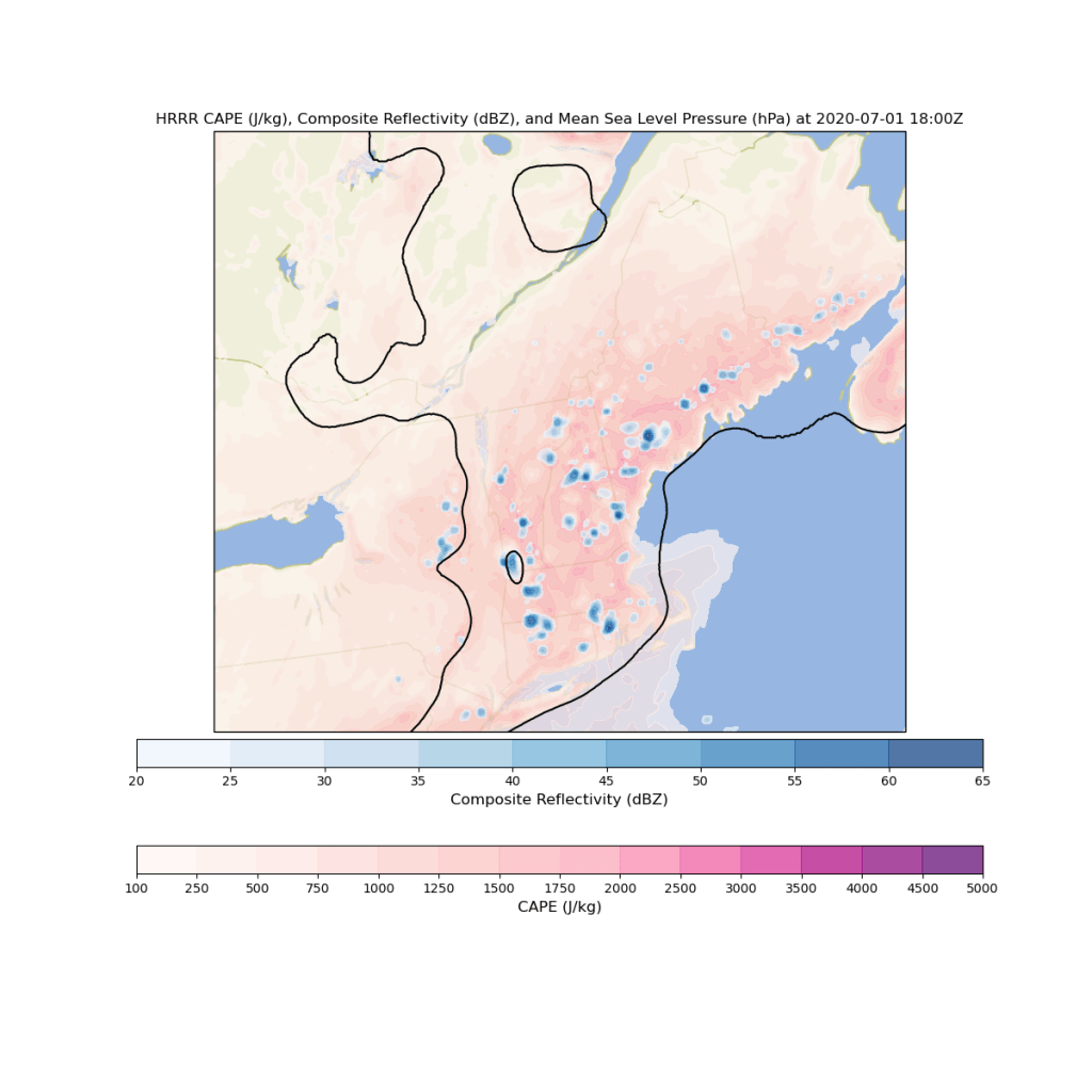
Satellite and radar imagery this morning shows a line of thunderstorms moving along the Canadian border just ahead of this frontal boundary while most of the region remains socked in with low clouds and patchy fog. This first line of thunderstorms should remain contained well north of Route Two and doesn’t appear to pose much if any severe threat. The low clouds across the rest of the area will be slow to burn off over the next few hours, but most spots should see at least a bit of sunshine by lunchtime.

Ahead of the boundary, southerly winds will continue transporting warm and humid air into the region. Dew points are in the mid 60s across most of the region this morning and will make a run at 70 by this afternoon. This means that developing storms will have an abundance of moisture to work with during the afternoon/evening hours. It also means that going outside today will feel akin to walking through a swamp in southern Florida.

Temperatures will rise into the mid 70s in the mountains and along the Midcoast and into the mid/upper 80s in most of southern NH and adjacent parts of interior SW ME as patchy sunshine develops over the next few hours.

By 1-2 PM, storms will be firing up in the mountains along the approaching cold front.

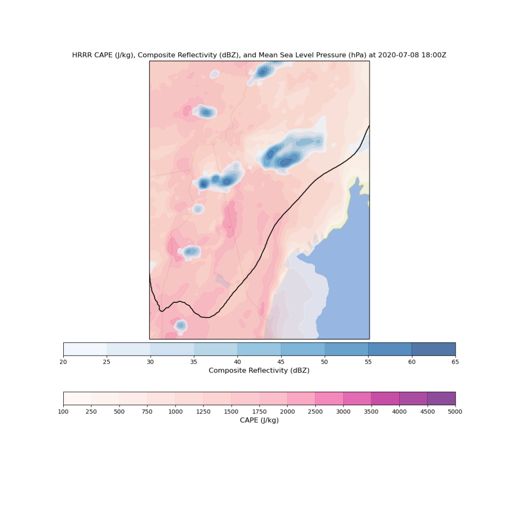
This afternoon’s storms will pose a much greater severe weather threat in addition to heavy rain and lightning. The biggest risk is damaging winds and flash flooding given the amount of moisture available. Storms will have a better shot at becoming severe if we’re able to erode these low-level clouds a bit earlier in the day.

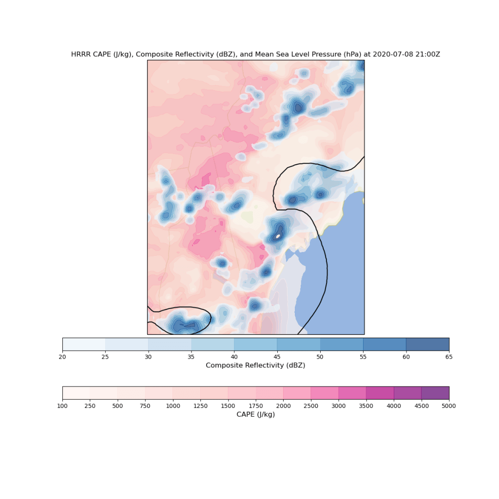
Storms will proceed towards the coastline later in the afternoon (above image valid 5 PM) before waning in coverage and intensity towards sunset.

Tomorrow’s weather looks absolutely horrific as temps soar towards 90 while dew points remain stuck near 70 (that’s a heat index of ~95+). Get those air conditioners ready!

Jack

Last Day of Acceptable Humidity (For A While) Today

Hello everyone,

Today’s forecast brings me great sadness, not because we’ll have to endure terrible weather, but because we’ll have to bid farewell to dew points anywhere near (let along below) 60.

Satellite imagery this morning shows a mix of sun and clouds across the area as low-level moisture leftover from yesterday’s onshore flow slowly disperses. Expect skies to gradually clear out through the rest of the morning. A few more clouds will arrive this afternoon/evening as our next frontal boundary begins drifting towards the region from the west. Just like yesterday, we’ll be mostly dry across the area today, but I can’t rule out a brief shower in the mountains later this afternoon.

Beginning tomorrow, we’ll have to endure an onslaught of tropical moisture. Dew points (the best way to measure how humid the air feels) will soar above 70 (that’s really humid) and stay there at least until Saturday or Sunday as a tropical system (potentially Tropical Storm Fay) moves up the coast. That system will bring heavy rain to the region on Saturday regardless of whether it acquires a name.

Get your air conditioners ready.

-Jack

Lovely Summer Weather Today

Hello everyone!

Today will feature picture-perfect summer weather after some morning stratus/fog burns off near the coast. Outside of these clouds, skies will be mostly sunny today as drier air drifts into the region from Canada. That drier airmass will also be enjoyed in the form of relatively lower humidity as dew points sink into the 50s for most of the area (around 60 at the coast). A stray shower might pop up in the mountains/foothills this afternoon but otherwise mostly dry weather is expected. High temps will range from 70 near the coast and up in the mountains to a little above 80 in southern NH. Enjoy the lovely day outside if you can!

-Jack

Another Round of Showers and Thunderstorms Today

Hello everyone!

Today will feature another round of showers and thunderstorms as a cold front swings into the region from Canada. Before those showers and storms begin developing this afternoon, we’ll be working on slowly burning off the layer of fog/stratus currently in place over the southeastern half of the area.

Satellite imagery shows slow progress being made towards clearing this morning. I think the fog/stratus layer will retreat to roughly the I-95 corridor by early/mid afternoon before getting stuck. So it’ll be another cloudy day along the coastline while inland areas should see at least a few hours of sunshine.

For those that do see sunshine today, temps will rise into the low/mid 80s. A few upper 80s are possible in southwestern NH. This warmth, combined with plenty of moisture left over from this morning’s marine layer will support thunderstorm development when a cold front arrives later this afternoon.

This forecast map shows several storms popping up in the mountains around 3-4 PM in a region of robust instability (but relatively light wind shear). Storms are likely to be more numerous as you head farther northeast where better forcing for ascent will be found. Storms that develop in the mountains in the mid/late afternoon will move southeast during the early evening, bringing heavy rain, lightning, and gusty winds to parts of the foothills. As these storms approach the coast, they will encounter a cooler airmass produced by the lack of direct sunlight under the marine stratus deck. As a result, storms will weaken quickly and no severe weather is expected (heavy rain and lightning still possible).

Temps along the coastline will top out in the upper 60s (near Rockland) to mid 70s (closer to Portland).

Showers and storms will remain in the mix for the first half of tonight as remnant storms move into the region from northern NY/VT. None of these are likely to be severe based on currently available information.

-Jack

Generally Quiet Weather Today

Hello everyone and happy Fourth of July!

Today will feature generally quiet weather across the area as a very weak cold front slides into the region from Canada. Satellite imagery this morning shows low clouds slowly burning off as daytime heating gets going. This trend will continue over the next few hours with clear skies expected area-wide by lunchtime.

Sunshine this afternoon will periodically be dimmed by passing cumulus clouds as some instability develops in response to warm temps and residual humidity (dew points near 60). A few of those cumulus cloud grow tall enough to produce a brief shower especially in the mountains and far northeastern parts of the area. Overall though, the vast majority of us will remain dry today.

Temps will top out in the mid 70s up north and along the coast with low 80s inland. Enjoy the beautiful weather!

-Jack

Cooler and Cloudier Today

Hello everyone!

Today will feature cooler temps and generally cloudier skies as winds shift around to the east/northeast and cooler air arrives from Canada and the Gulf of Maine. High temps will range from the upper 60s along the coastline to the mid 70s in northeastern parts of the interior where sunshine will emerge later this afternoon.

Most of Maine is experiencing low clouds or fog as I write this shortly before 5:30 AM while New Hampshire, still mostly ahead of the front, is partly cloudy. Expect the Maine fog bank to continue sliding southwest this morning along with the front. As we move later into the afternoon. the fog will attempt to burn off. This effort is likely to be most successful in the foothills and mountains where sunshine will emerge as the prevailing weather condition by mid/late afternoon.

Overall, precipitation chances will be limited today. Some drizzle is possible along the coast in the fog bank and a couple scattered showers will likely pop up in the mountains of NH this afternoon but otherwise dry conditions are expected.

-Jack

Another Round of Showers and Thunderstorms Arrives This Afternoon

Hello everyone!

Today, we’ll finally be getting rid of the upper-level low that has brought unsettled conditions to the region since Sunday. However, to do so, we’ll need a cold front to sweep through the region from north to south. That front will provide forcing for ascent for strong to severe thunderstorms especially in northeastern parts of the area this afternoon.

Before we get to the storms this afternoon, we’ll start off with widespread low clouds and fog this morning. Some of this fog is quite dense with visibilities of less than a quarter mile. Low clouds and fog will burn off over the next couple hours, leaving mostly sunny skies by noon.

That sunshine will push temps well above what they have been this week under the influence of the upper-level low. Highs will range from 75 in the mountains and along the coastline to near 90 along the coastal plain. Unfortunately, dew points will surge into the mid/upper 60s which means it will feel hot and muggy.

Any time a cold front slices through a hot and humid airmass, we start thinking about thunderstorms. This afternoon is no exception. Expect showers and storms to begin popping up over the mountains around 2-3 PM before moving southeast later in the afternoon. The central part of the region from Fryeburg to Belfast will be most unstable, and the best forcing for ascent (the initial upward nudge thunderstorms need to develop) will be found over eastern parts of the area. As a result, the best chance for strong thunderstorms will be found over central/eastern parts of the area from Penobscot Bay north into Somerset County and west towards the Lewiston/Farmington corridor.

This is generally consistent with model forecasts. That said, I also suspect we’ll see a few storms initiate from terrain forcing over the White Mountains before proceeding south-southwest into Oxford, Cumberland, and York counties. These won’t be as widespread as the storms farther east, but I think we’ll see at least one or two. Storms today will produce lightning, damaging winds, and heavy rain.

Cooler and drier weather arrives tomorrow.

-Jack

More of the Same Unsettled Weather Today

Hello everyone!

Today’s weather across New England will look a lot like yesterday’s as the upper-level low responsible for our periodic rounds of rain remains stuck overhead. As of 5:15 AM, most of the region is socked in with either low clouds (inland/mountains) or fog (coastal plain). That will gradually change as we move later into the afternoon when breaks of sun are expected to pop up. These patches of sunshine won’t last all that long as instability increases and another round of showers/storms develops.

Just like yesterday, showers and storms won’t be distributed equally around the entire area. Some towns will get over an inch of rain from a slow-moving thunderstorm and the next towns over might not even see a drop. The most widespread showers/storms will once again be away from the coastline. Just like the past few days, the primary threats from showers and storms today are lightning and heavy rain. Upper-level winds aren’t strong enough to support much of a severe weather threat.

High temps today will remain on the cooler side, ranging from 70 in the northern mountains to 75 in the foothills.

-Jack